
Hoskins topographic map
Interactive map
Click on the map to display elevation.
About this map
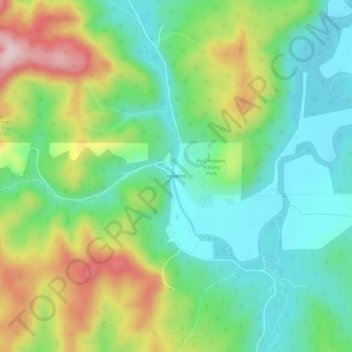
Name: Hoskins topographic map, elevation, terrain.
Location: Hoskins, Benton County, Oregon, United States (44.65634 -123.48767 44.69634 -123.44767)
Average elevation: 191 m
Minimum elevation: 86 m
Maximum elevation: 391 m
Other topographic maps
Click on a map to view its topography, its elevation and its terrain.
Corvallis
United States > Oregon > Benton County
Corvallis, Benton County, Oregon, United States
Average elevation: 81 m
Adair Village
United States > Oregon > Benton County
Adair Village, Benton County, Oregon, United States
Average elevation: 100 m
Harris
United States > Oregon > Benton County
Harris, Benton County, Oregon, United States
Average elevation: 257 m
Glenbrook
United States > Oregon > Benton County
Glenbrook, Benton County, Oregon, United States
Average elevation: 180 m
Alpine
United States > Oregon > Benton County
Alpine, Benton County, Oregon, 97456, United States
Average elevation: 112 m
Monroe
United States > Oregon > Benton County
Monroe, Benton County, Oregon, United States
Average elevation: 99 m
Lewisburg
United States > Oregon > Benton County
Lewisburg, Benton County, Oregon, United States
Average elevation: 101 m
Noon
United States > Oregon > Benton County
Noon, Benton County, Oregon, 97370, United States
Average elevation: 143 m
Kings Valley
United States > Oregon > Benton County
Kings Valley, Benton County, Oregon, United States
Average elevation: 125 m
Coast Range
United States > Oregon > Benton County
Coast Range, Benton County, Oregon, United States
Average elevation: 824 m
Philomath
United States > Oregon > Benton County
Philomath, Benton County, Oregon, 97370, United States
Average elevation: 104 m
Flynn
United States > Oregon > Benton County
Flynn, Benton County, Oregon, 97370, United States
Average elevation: 124 m
Alder
United States > Oregon > Benton County
Alder, Benton County, Oregon, 97326, United States
Average elevation: 244 m
Bellfountain
United States > Oregon > Benton County
Bellfountain, Benton County, Oregon, United States
Average elevation: 107 m
Summit
United States > Oregon > Benton County
Summit, Benton County, Oregon, 96326, United States
Average elevation: 218 m
Marys Peak
United States > Oregon > Benton County
Marys Peak, Benton County, Oregon, United States
Average elevation: 874 m
Blodgett
United States > Oregon > Benton County
Blodgett, Benton County, Oregon, 97326, United States
Average elevation: 230 m
Alsea
United States > Oregon > Benton County
Alsea, Benton County, Oregon, 97324, United States
Average elevation: 154 m