
Thank you for supporting this site ❤️
Make a donation
Make a donation
Mildura topographic map
Click on the map to display elevation.
Thank you for supporting this site ❤️
Make a donation
Make a donation
About this map
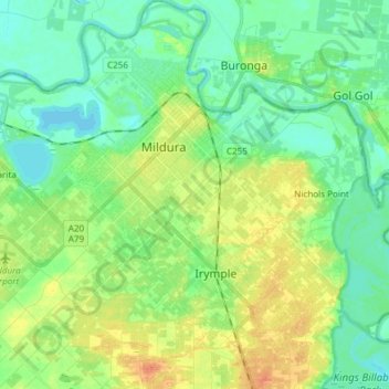
Name: Mildura topographic map, elevation, terrain.
Location: Mildura, Rural City of Mildura, Victoria, 3500, Australia (-34.27277 142.06324 -34.14871 142.20397)
Average elevation: 47 m
Minimum elevation: 32 m
Maximum elevation: 71 m
Thank you for supporting this site ❤️
Make a donation
Make a donation
Other topographic maps
Click on a map to view its topography, its elevation and its terrain.