
Wettin topographic map
Interactive map
Click on the map to display elevation.
About this map
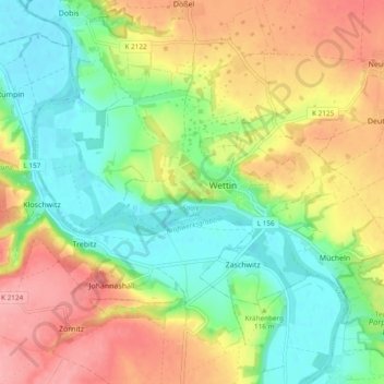
Name: Wettin topographic map, elevation, terrain.
Average elevation: 115 m
Minimum elevation: 66 m
Maximum elevation: 178 m
Other topographic maps
Click on a map to view its topography, its elevation and its terrain.
Lettewitz
Deutschland > Sachsen-Anhalt > Saalekreis > Wettin-Löbejün
Lettewitz, Wettin-Löbejün, Saalekreis, Sachsen-Anhalt, Deutschland
Average elevation: 141 m
Löbejün
Deutschland > Sachsen-Anhalt > Saalekreis > Wettin-Löbejün
Löbejün, Wettin-Löbejün, Saalekreis, Sachsen-Anhalt, Deutschland
Average elevation: 111 m
Dößel
Deutschland > Sachsen-Anhalt > Saalekreis > Wettin-Löbejün
Dößel, Wettin-Löbejün, Saalekreis, Sachsen-Anhalt, Deutschland
Average elevation: 130 m