
Landsborough topographic map
Interactive map
Click on the map to display elevation.
About this map
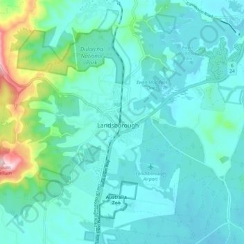
Name: Landsborough topographic map, elevation, terrain.
Location: Landsborough, Sunshine Coast, Queensland, 4550, Australia (-26.84938 152.92568 -26.76938 153.00568)
Average elevation: 69 m
Minimum elevation: 6 m
Maximum elevation: 406 m
Other topographic maps
Click on a map to view its topography, its elevation and its terrain.
Ewen Maddock Dam
Australia > Queensland > Landsborough
Ewen Maddock Dam, Ferny Forest Loop, Landsborough, Queensland, Australia
Average elevation: 31 m
Dularcha National Park
Australia > Queensland > Landsborough > Mooloolah
Dularcha National Park, Dlurcha Drive, Landsborough, Queensland, 4553, Australia
Average elevation: 75 m