
Goffstown topographic map
Interactive map
Click on the map to display elevation.
About this map
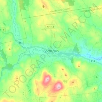
Name: Goffstown topographic map, elevation, terrain.
Average elevation: 159 m
Minimum elevation: 49 m
Maximum elevation: 402 m
The surface is comparatively level, the only elevations of note being two in the southwest part, called by the natives Uncanoonuck. There are considerable tracts of valuable interval, as well as extensive plains, which are generally productive. Piscataquog river is the principal stream, which furnishes quite a number of valuable mill privileges. It passes through in a central direction. Large quantities of lumber were formerly floated down this stream to the Merrimack, and the forests at one time supplied a large number of masts for the English navy. The New Hampshire Central Railroad passes through Goffstown. Then; are three villages — Goffstown, Goffstown Centre, and Parker's Mills; three church edifices — Baptist, Congregational, and Methodist; sixteen school districts; and two post-offices — Goffstown and Goffstown Centre: also, four stores, four saw-mills, two grist-mills, and one sash and blind factory. Population, 2,270; valuation, $599,615.
Other topographic maps
Click on a map to view its topography, its elevation and its terrain.
Brookline
United States > New Hampshire > Hillsborough County
Brookline, Hillsborough County, New Hampshire, 03033, United States
Average elevation: 126 m
Milford
United States > New Hampshire > Hillsborough County
Milford, Hillsborough County, New Hampshire, 03055, United States
Average elevation: 114 m
Peterborough
United States > New Hampshire > Hillsborough County
Peterborough, Hillsborough County, New Hampshire, United States
Average elevation: 304 m
Bennington
United States > New Hampshire > Hillsborough County
Bennington, Hillsborough County, New Hampshire, 03442, United States
Average elevation: 260 m
Hillsboro Lower Village
United States > New Hampshire > Hillsborough County > Hillsborough
Hillsboro Lower Village, Hillsborough, Hillsborough County, New Hampshire, 03244, United States
Average elevation: 242 m
Campbell Mountain
United States > New Hampshire > Hillsborough County > Hillsborough
Campbell Mountain, Hillsborough, Hillsborough County, New Hampshire, United States
Average elevation: 338 m
Hollis
United States > New Hampshire > Hillsborough County
Hollis, Hillsborough County, New Hampshire, United States
Average elevation: 101 m
Temple
United States > New Hampshire > Hillsborough County
Temple, Hillsborough County, New Hampshire, 03084, United States
Average elevation: 346 m
Massachusetts Drive Park
United States > New Hampshire > Hillsborough County > Nashua
Massachusetts Drive Park, Ward 7, Nashua, Hillsborough County, New Hampshire, United States
Average elevation: 48 m
Greenfield
United States > New Hampshire > Hillsborough County > Greenfield
Greenfield, Hillsborough County, New Hampshire, 03047, United States
Average elevation: 288 m
Wilton
United States > New Hampshire > Hillsborough County
Wilton, Hillsborough County, New Hampshire, 03086, United States
Average elevation: 179 m
North Brookline
United States > New Hampshire > Hillsborough County > Brookline > North Brookline
North Brookline, Brookline, Hillsborough County, New Hampshire, 03033, United States
Average elevation: 124 m
Nashua
United States > New Hampshire > Hillsborough County
Nashua, Hillsborough County, New Hampshire, United States
Average elevation: 62 m
South Weare
United States > New Hampshire > Hillsborough County > Weare > South Weare
South Weare, Weare, Hillsborough County, New Hampshire, 03281, United States
Average elevation: 210 m
Nashua
United States > New Hampshire > Hillsborough County > Nashua
Nashua, Hillsborough County, New Hampshire, 03060-03064, United States
Average elevation: 82 m
Weare
United States > New Hampshire > Hillsborough County
Weare, Hillsborough County, New Hampshire, United States
Average elevation: 210 m
Hudson
United States > New Hampshire > Hillsborough County
Hudson, Hillsborough County, New Hampshire, 03051, United States
Average elevation: 68 m
Nakuru Lake
United States > New Hampshire > Hillsborough County > Hudson > Hudson Center
Nakuru Lake, Hudson Center, Hudson, Hillsborough County, New Hampshire, United States
Average elevation: 80 m
Manchester
United States > New Hampshire > Hillsborough County
Manchester, Hillsborough County, New Hampshire, United States
Average elevation: 96 m
New Boston
United States > New Hampshire > Hillsborough County
New Boston, Hillsborough County, New Hampshire, 03070, United States
Average elevation: 193 m
Hillsborough
United States > New Hampshire > Hillsborough County
Hillsborough, Hillsborough County, New Hampshire, 03244, United States
Average elevation: 298 m
Pelham
United States > New Hampshire > Hillsborough County
Pelham, Hillsborough County, New Hampshire, 03076, United States
Average elevation: 69 m
Amherst
United States > New Hampshire > Hillsborough County > Amherst
Amherst, Hillsborough County, New Hampshire, 03031, United States
Average elevation: 127 m
Merrimack
United States > New Hampshire > Hillsborough County > Merrimack
Merrimack, Hillsborough County, New Hampshire, 03054, United States
Average elevation: 68 m
Bedford
United States > New Hampshire > Hillsborough County
Bedford, Hillsborough County, New Hampshire, 03110, United States
Average elevation: 97 m