
Mount Moriah topographic map
Interactive map
Click on the map to display elevation.
About this map
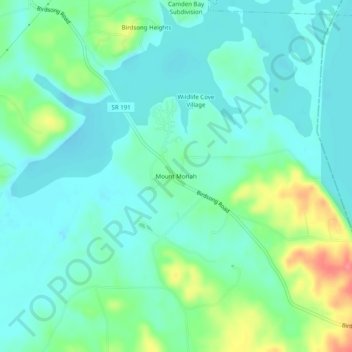
Name: Mount Moriah topographic map, elevation, terrain.
Average elevation: 123 m
Minimum elevation: 103 m
Maximum elevation: 182 m
Other topographic maps
Click on a map to view its topography, its elevation and its terrain.
Beaverdam Creek Subdivision
United States > Tennessee > Benton County
Beaverdam Creek Subdivision, Benton County, West Tennessee, Tennessee, 38333, United States
Average elevation: 121 m
Sawyers Mill
United States > Tennessee > Benton County
Sawyers Mill, Benton County, West Tennessee, Tennessee, United States
Average elevation: 140 m
Kentucky Lake
United States > Tennessee > Benton County
Kentucky Lake, Benton County, West Tennessee, Tennessee, United States
Average elevation: 169 m
Nathan Bedford Forrest State Park
United States > Tennessee > Benton County
Nathan Bedford Forrest State Park, Benton County, West Tennessee, Tennessee, 38333, United States
Average elevation: 135 m
Chestnut Hill
United States > Tennessee > Benton County > Chestnut Hill
Chestnut Hill, Benton County, Tennessee, 38333, United States
Average elevation: 165 m