
Thank you for supporting this site ❤️
Make a donation
Make a donation
Rauschberg topographic map
Click on the map to display elevation.
Thank you for supporting this site ❤️
Make a donation
Make a donation
Rauschberg
Der Rauschberg ist ein mehrgipfeliger Gebirgsstock in den Chiemgauer Alpen mit einer maximalen Höhe von 1671 m ü. NHN.
Thank you for supporting this site ❤️
Make a donation
Make a donation
About this map
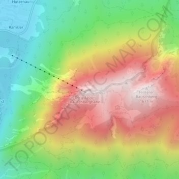
Name: Rauschberg topographic map, elevation, terrain.
Average elevation: 1,115 m
Minimum elevation: 667 m
Maximum elevation: 1,635 m
Thank you for supporting this site ❤️
Make a donation
Make a donation
Other topographic maps
Click on a map to view its topography, its elevation and its terrain.