
Mont Saint-Hilaire topographic map
Interactive map
Click on the map to display elevation.
About this map
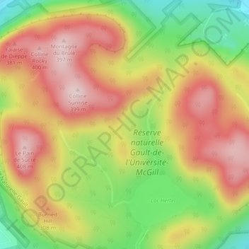
Name: Mont Saint-Hilaire topographic map, elevation, terrain.
Average elevation: 247 m
Minimum elevation: 66 m
Maximum elevation: 396 m
Other topographic maps
Click on a map to view its topography, its elevation and its terrain.
La Quenouillère
Canada > Quebec > La Vallée-du-Richelieu > Mont-Saint-Hilaire
La Quenouillère, Mont-Saint-Hilaire, La Vallée-du-Richelieu, Montérégie, Quebec, J3H 6C2, Canada
Average elevation: 182 m