
凤山乡 topographic map
Interactive map
Click on the map to display elevation.
About this map
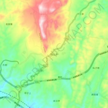
Name: 凤山乡 topographic map, elevation, terrain.
Location: 凤山乡, 大方县, 毕节市, 贵州省, 中国 (27.17880 105.69100 27.25880 105.77100)
Average elevation: 1,718 m
Minimum elevation: 1,496 m
Maximum elevation: 2,076 m
Other topographic maps
Click on a map to view its topography, its elevation and its terrain.