
Ortre topographic map
Interactive map
Click on the map to display elevation.
About this map
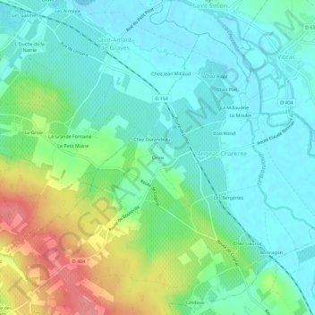
Name: Ortre topographic map, elevation, terrain.
Average elevation: 38 m
Minimum elevation: 13 m
Maximum elevation: 100 m
Other topographic maps
Click on a map to view its topography, its elevation and its terrain.
Les Bergeries
France > Nouvelle-Aquitaine > Charente > Angeac-Charente
Les Bergeries, Angeac-Charente, Cognac, Charente, Nouvelle-Aquitaine, France métropolitaine, 16120, France
Average elevation: 38 m
Chez Durandeau
France > Nouvelle-Aquitaine > Charente > Angeac-Charente
Chez Durandeau, Angeac-Charente, Cognac, Charente, Nouvelle-Aquitaine, France métropolitaine, 16120, France
Average elevation: 37 m
Angeac-Charente
France > Nouvelle-Aquitaine > Charente > Angeac-Charente
Angeac-Charente, Cognac, Charente, Nouvelle-Aquitaine, France métropolitaine, 16120, France
Average elevation: 40 m