
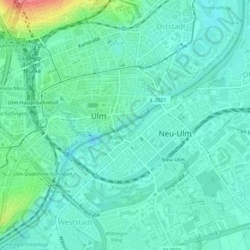
Kleine Donau topographic map
Interactive map
Click on the map to display elevation.
About this map
Name: Kleine Donau topographic map, elevation, terrain.
Average elevation: 478 m
Minimum elevation: 460 m
Maximum elevation: 546 m
Other topographic maps
Click on a map to view its topography, its elevation and its terrain.
Schwaighofen
Deutschland > Bayern > Landkreis Neu-Ulm > Neu-Ulm
Schwaighofen, Neu-Ulm, Landkreis Neu-Ulm, Bayern, Deutschland
Average elevation: 475 m
Jedelhausen
Deutschland > Bayern > Landkreis Neu-Ulm > Neu-Ulm
Jedelhausen, Neu-Ulm, Landkreis Neu-Ulm, Bayern, Deutschland
Average elevation: 500 m
Schloss
Deutschland > Bayern > Landkreis Neu-Ulm > Neu-Ulm > Holzschwang
Schloss, Weißenhorner Straße, Holzschwang, Neu-Ulm, Landkreis Neu-Ulm, Bayern, 89233, Deutschland
Average elevation: 503 m
Gerlenhofen
Deutschland > Bayern > Landkreis Neu-Ulm > Neu-Ulm
Gerlenhofen, Neu-Ulm, Landkreis Neu-Ulm, Bayern, Deutschland
Average elevation: 489 m
Steinheim
Deutschland > Bayern > Landkreis Neu-Ulm > Neu-Ulm
Steinheim, Neu-Ulm, Landkreis Neu-Ulm, Bayern, Deutschland
Average elevation: 473 m