
Thank you for supporting this site ❤️
Make a donation
Make a donation
Oras topographic map
Click on the map to display elevation.
Thank you for supporting this site ❤️
Make a donation
Make a donation
About this map
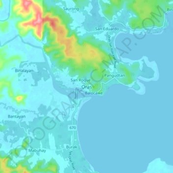
Name: Oras topographic map, elevation, terrain.
Location: Oras, Eastern Samar, Eastern Visayas, Philippines (12.10103 125.40084 12.18103 125.48084)
Average elevation: 14 m
Minimum elevation: -3 m
Maximum elevation: 128 m
Thank you for supporting this site ❤️
Make a donation
Make a donation