
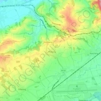
Kirchberg-Thening topographic map
Interactive map
Click on the map to display elevation.
About this map
Name: Kirchberg-Thening topographic map, elevation, terrain.
Average elevation: 318 m
Minimum elevation: 257 m
Maximum elevation: 436 m
Kirchberg-Thening liegt auf 357 m Höhe im oberösterreichischen Zentralraum. Die Ausdehnung beträgt von Nord nach Süd 3,9 km, von West nach Ost 7,4 km. Die Gesamtfläche beträgt 15,9 km². 10,1 % der Fläche sind bewaldet, 76,1 % der Fläche sind landwirtschaftlich genutzt.
Other topographic maps
Click on a map to view its topography, its elevation and its terrain.
Reith
Österreich > Oberösterreich > Bezirk Linz-Land > Leonding
Reith, Leonding, Bezirk Linz-Land, Oberösterreich, 4060, Österreich
Average elevation: 289 m
Traun
Österreich > Oberösterreich > Bezirk Linz-Land
Traun, Bezirk Linz-Land, Oberösterreich, 4050, Österreich
Average elevation: 279 m
Leonding
Österreich > Oberösterreich > Bezirk Linz-Land
Leonding, Bezirk Linz-Land, Oberösterreich, 4060, Österreich
Average elevation: 307 m
Öhndorf
Österreich > Oberösterreich > Bezirk Linz-Land > Neubau > Öhndorf
Öhndorf, Neubau, Hörsching, Bezirk Linz-Land, Oberösterreich, 4063, Österreich
Average elevation: 286 m
Pucking
Österreich > Oberösterreich > Bezirk Linz-Land > Pucking
Pucking, Bezirk Linz-Land, Oberösterreich, 4055, Österreich
Average elevation: 314 m
Ansfelden
Österreich > Oberösterreich > Bezirk Linz-Land
Ansfelden, Bezirk Linz-Land, Oberösterreich, 4053, Österreich
Average elevation: 302 m