
Hohenbocka topographic map
Interactive map
Click on the map to display elevation.
About this map
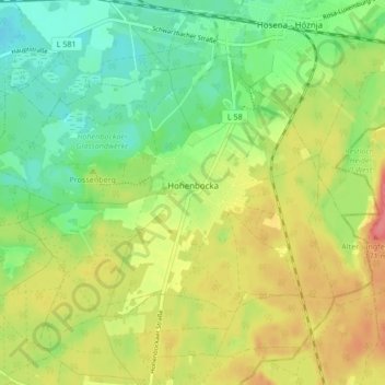
Name: Hohenbocka topographic map, elevation, terrain.
Average elevation: 126 m
Minimum elevation: 96 m
Maximum elevation: 153 m
Other topographic maps
Click on a map to view its topography, its elevation and its terrain.
Calau
Deutschland > Brandenburg > Oberspreewald-Lausitz
Calau, Oberspreewald-Lausitz, Brandenburg, 03205, Deutschland
Average elevation: 83 m
Weißag
Deutschland > Brandenburg > Oberspreewald-Lausitz > Luckaitztal
Weißag, Luckaitztal, Altdöbern, Oberspreewald-Lausitz, Brandenburg, 03229, Deutschland
Average elevation: 127 m
Koßwig
Deutschland > Brandenburg > Oberspreewald-Lausitz > Vetschau/Spreewald
Koßwig, Vetschau/Spreewald, Oberspreewald-Lausitz, Brandenburg, Deutschland
Average elevation: 67 m
Senftenberg
Deutschland > Brandenburg > Oberspreewald-Lausitz
Senftenberg, Oberspreewald-Lausitz, Brandenburg, Deutschland
Average elevation: 110 m
Lübbenau/Spreewald
Deutschland > Brandenburg > Oberspreewald-Lausitz
Lübbenau/Spreewald, Oberspreewald-Lausitz, Brandenburg, 03222, Deutschland
Average elevation: 60 m
Lauchhammer
Deutschland > Brandenburg > Oberspreewald-Lausitz > Lauchhammer
Lauchhammer, Oberspreewald-Lausitz, Brandenburg, 01979, Deutschland
Average elevation: 107 m