
Make a donation
Tuensang topographic map
Click on the map to display elevation.
Make a donation
About this map
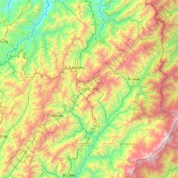
Name: Tuensang topographic map, elevation, terrain.
Location: Tuensang, Nagaland, India (26.01087 94.55867 26.45768 94.94222)
Average elevation: 1,297 m
Minimum elevation: 317 m
Maximum elevation: 2,638 m
Make a donation
Other topographic maps
Click on a map to view its topography, its elevation and its terrain.
Make a donation
Make a donation
Make a donation
Make a donation
Kohima
India > Nagaland > Kohima Sadar
Kohima (/koʊˈhiːmə/ ; Angami Naga: Kewhira (IPA: [ˈkɛʍɪɻə])) is the capital of the North East Indian state of Nagaland. With a resident population of almost 100,000, it is the second largest city in the state. Kohima constitutes both a district and a municipality. The municipality covers 20 km2 (7.7…
Average elevation: 1,425 m
Make a donation
Kohima
India > Nagaland > Kohima Sadar
Kohima (/koʊˈhiːmə/ ; Angami Naga: Kewhira (IPA: [ˈkɛʍɪɻə]) is the capital of the Indian state of Nagaland. With a resident population of almost 100,000, it is the second largest city in the state. Kohima constitutes both a district and a municipality. The municipality covers 20 km2 (7.7 sq mi). The…
Average elevation: 1,425 m
Make a donation
Make a donation