
Millstream topographic map
Interactive map
Click on the map to display elevation.
About this map
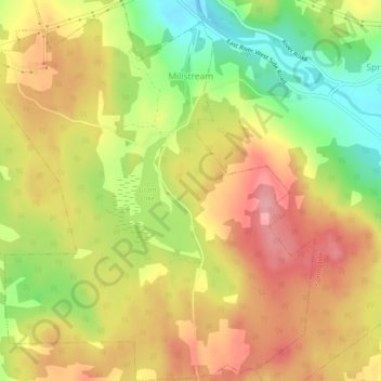
Name: Millstream topographic map, elevation, terrain.
Average elevation: 114 m
Minimum elevation: 45 m
Maximum elevation: 170 m
Other topographic maps
Click on a map to view its topography, its elevation and its terrain.
Scotch Hill
Canada > Nouvelle-Écosse > Municipality of Pictou County
Scotch Hill, Municipality of Pictou County, Pictou County, Nouvelle-Écosse, Canada
Average elevation: 52 m