
Boone County topographic map
Interactive map
Click on the map to display elevation.
About this map
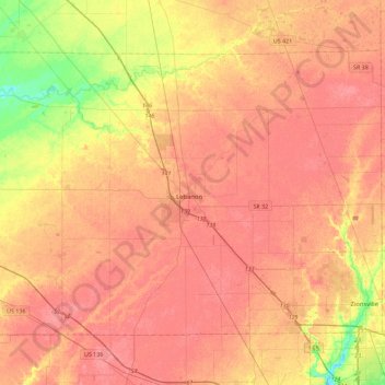
Name: Boone County topographic map, elevation, terrain.
Location: Boone County, Indiana, United States (39.92241 -86.69605 40.18082 -86.24075)
Average elevation: 280 m
Minimum elevation: 240 m
Maximum elevation: 299 m
Other topographic maps
Click on a map to view its topography, its elevation and its terrain.
Indianapolis
United States > Indiana > Indianapolis
Indianapolis is within the Tipton Till Plain, a flat to gently sloping terrain underlain by glacial deposits known as till. The lowest point in the city is about 650 feet (198 m) above mean sea level, with the highest natural elevation at about 900 feet (274 m) above sea level. Few hills or short ridges, known…
Average elevation: 241 m
Johnson Lake
United States > Indiana > Jefferson County > Madison > North Madison
Average elevation: 266 m
Fort Benjamin Harrison State Park and Nature Preserve
United States > Indiana > Marion County > Indianapolis
Average elevation: 254 m
Country Club Meadows
United States > Indiana > Vanderburgh County > Evansville
Average elevation: 126 m