
Gavdos topographic map
Interactive map
Click on the map to display elevation.
About this map
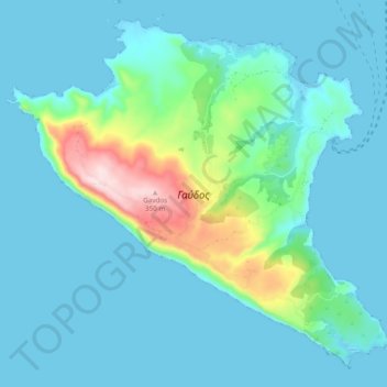
Name: Gavdos topographic map, elevation, terrain.
Average elevation: 56 m
Minimum elevation: -2 m
Maximum elevation: 368 m
Other topographic maps
Click on a map to view its topography, its elevation and its terrain.
Lefkogia
Greece > Region of Crete > Rethymno Regional Unit
Lefkogia, Municipality of Agios Vasileios, Rethymno Regional Unit, Region of Crete, 740 60, Greece
Average elevation: 150 m
Traostalos
Greece > Region of Crete > Lasithi Regional Unit > Itanos Municipal Unit
Traostalos, Itanos Municipal Unit, Municipality of Sitia, Lasithi Regional Unit, Region of Crete, Greece
Average elevation: 272 m
Panormos
Greece > Region of Crete > Panormos
Panormos, District of Milopotamos, Rethymno Regional Unit, Region of Crete, 740 57, Greece
Average elevation: 32 m
District of Chania
Greece > Region of Crete > District of Chania
District of Chania, Chania Regional Unit, Region of Crete, Greece
Average elevation: 353 m