Geolocate

Eagar topographic map

Click on the map to display elevation.

About this map

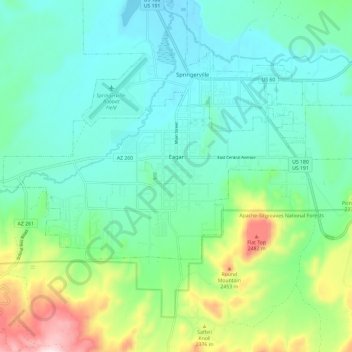
Name: Eagar topographic map, elevation, terrain.

Location: Eagar, Apache County, Arizona, 85925, United States (34.08253 -109.34972 34.12909 -109.23158)

Average elevation: 2,227 m

Minimum elevation: 2,105 m

Maximum elevation: 2,601 m

Other topographic maps

Click on a map to view its topography, its elevation and its terrain.

Greer

United States > Arizona > Apache County

Average elevation: 2,669 m

Sanders

United States > Arizona > Apache County

Average elevation: 1,801 m

Fort Defiance

United States > Arizona > Apache County

Average elevation: 2,130 m

East Mesa

United States > Arizona > Apache County

Average elevation: 2,093 m

Spider Rock

United States > Arizona > Apache County

Average elevation: 1,954 m

Concho

United States > Arizona > Apache County

Average elevation: 1,844 m

Lupton

United States > Arizona > Apache County

Average elevation: 1,942 m

Chambers

United States > Arizona > Apache County

Average elevation: 1,776 m

Vernon

United States > Arizona > Apache County

Average elevation: 2,119 m

Many Farms

United States > Arizona > Apache County

Average elevation: 1,641 m

Red Hill

United States > Arizona > Apache County

Average elevation: 1,830 m

Sawmill

United States > Arizona > Apache County

Average elevation: 2,354 m

Lukachukai

United States > Arizona > Apache County

Average elevation: 2,004 m

Vernon

United States > Arizona > Apache County

Average elevation: 2,119 m

Chinle

United States > Arizona > Apache County > Chinle

Average elevation: 1,715 m

Nutrioso

United States > Arizona > Apache County

Average elevation: 2,404 m

Toyei

United States > Arizona > Apache County

Average elevation: 1,993 m

Concho

United States > Arizona > Apache County

Average elevation: 1,844 m

Red Rock

United States > Arizona > Apache County

Average elevation: 1,780 m

Michigan Lake

United States > Arizona > Apache County

Average elevation: 1,888 m

St. Michaels

United States > Arizona > Apache County

Average elevation: 2,066 m

Concho

United States > Arizona > Apache County > Concho

Average elevation: 1,844 m

Eagle Crag

United States > Arizona > Apache County

Average elevation: 1,970 m

Red Rock

United States > Arizona > Apache County

Average elevation: 1,780 m