
Folgosa topographic map
Interactive map
Click on the map to display elevation.
About this map
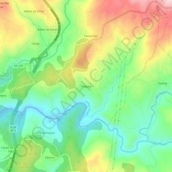
Name: Folgosa topographic map, elevation, terrain.
Location: Folgosa, Castro Daire, Viseu, 3600-143, Portugal (40.87488 -7.91808 40.91488 -7.87808)
Average elevation: 596 m
Minimum elevation: 461 m
Maximum elevation: 806 m
Other topographic maps
Click on a map to view its topography, its elevation and its terrain.
Ermida
Portugal > Viseu > Castro Daire
Ermida, Picão e Ermida, Castro Daire, Viseu, Portugal
Average elevation: 554 m
Cêtos
Portugal > Viseu > Castro Daire > Pinheiro
Cêtos, Pinheiro, Castro Daire, Viseu, Portugal
Average elevation: 737 m
Monteiras
Portugal > Viseu > Castro Daire
Monteiras, Castro Daire, Viseu, Portugal
Average elevation: 898 m
Gosende
Portugal > Viseu > Castro Daire
Gosende, Castro Daire, Viseu, Portugal
Average elevation: 1,011 m
Almofala
Portugal > Viseu > Castro Daire
Almofala, Castro Daire, Viseu, 3600-011, Portugal
Average elevation: 899 m