
Aïn Foua topographic map
Interactive map
Click on the map to display elevation.
About this map
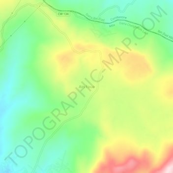
Name: Aïn Foua topographic map, elevation, terrain.
Location: Aïn Foua, Oued Athmania, Daïra Chelghoum Laïd, Mila, Algérie (36.29568 6.37404 36.33568 6.41404)
Average elevation: 1,024 m
Minimum elevation: 877 m
Maximum elevation: 1,251 m
Other topographic maps
Click on a map to view its topography, its elevation and its terrain.
Ain Kermat
Algérie > Mila > Daïra Chelghoum Laïd > Oued Athmania
Ain Kermat, Oued Athmania, Daïra Chelghoum Laïd, Mila, Algérie
Average elevation: 987 m
Ain Salah
Algérie > Mila > Daïra Chelghoum Laïd > Oued Athmania
Ain Salah, Route Oued Othmania, Oued Athmania, Daïra Chelghoum Laïd, Mila, Algérie
Average elevation: 843 m