
Thank you for supporting this site ❤️
Make a donation
Make a donation
Nordstetten topographic map
Click on the map to display elevation.
Thank you for supporting this site ❤️
Make a donation
Make a donation
About this map
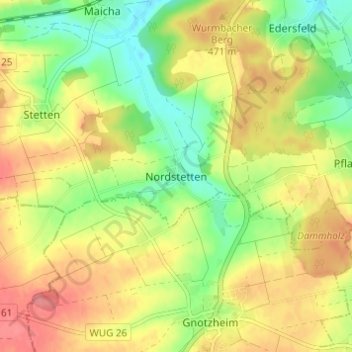
Name: Nordstetten topographic map, elevation, terrain.
Average elevation: 463 m
Minimum elevation: 425 m
Maximum elevation: 499 m
Thank you for supporting this site ❤️
Make a donation
Make a donation
Other topographic maps
Click on a map to view its topography, its elevation and its terrain.
Altmühlsee
Deutschland > Bayern > Landkreis Weißenburg-Gunzenhausen > Gunzenhausen > Streudorf
Average elevation: 417 m
91710
Deutschland > Bayern > Landkreis Weißenburg-Gunzenhausen > Gunzenhausen > Schlungenhof > Scheupeleinsmühle
Average elevation: 418 m