
Oued Sly topographic map
Interactive map
Click on the map to display elevation.
About this map
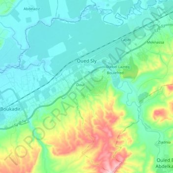
Name: Oued Sly topographic map, elevation, terrain.
Location: Oued Sly, Daïra Boukadir, Chlef, 02011, Algérie (36.01635 1.13605 36.14748 1.29316)
Average elevation: 163 m
Minimum elevation: 67 m
Maximum elevation: 491 m
Other topographic maps
Click on a map to view its topography, its elevation and its terrain.
Boukadir
Algérie > Chlef > Daïra Boukadir
Boukadir, Daïra Boukadir, Chlef, Algérie
Average elevation: 263 m
Abdelaziz
Algérie > Chlef > Daïra Boukadir
Abdelaziz, Sobha, Daïra Boukadir, Chlef, Algérie
Average elevation: 91 m