
Thank you for supporting this site ❤️
Make a donation
Make a donation
Saint Cloud topographic map
Click on the map to display elevation.
Thank you for supporting this site ❤️
Make a donation
Make a donation
About this map
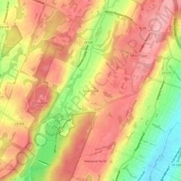
Name: Saint Cloud topographic map, elevation, terrain.
Average elevation: 141 m
Minimum elevation: 45 m
Maximum elevation: 202 m
Thank you for supporting this site ❤️
Make a donation
Make a donation
Other topographic maps
Click on a map to view its topography, its elevation and its terrain.
Pleasantdale
United States > New Jersey > Essex County > West Orange > Pleasantdale
Average elevation: 152 m
Pleasantdale
United States > New Jersey > Essex County > West Orange > Pleasantdale
Average elevation: 152 m
Thank you for supporting this site ❤️
Make a donation
Make a donation