
Morristown topographic map
Interactive map
Click on the map to display elevation.
About this map
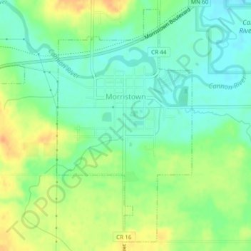
Name: Morristown topographic map, elevation, terrain.
Location: Morristown, Rice County, Minnesota, United States (44.21082 -93.46454 44.23582 -93.43436)
Average elevation: 316 m
Minimum elevation: 301 m
Maximum elevation: 336 m
Other topographic maps
Click on a map to view its topography, its elevation and its terrain.
Faribault
United States > Minnesota > Rice County
Faribault, Rice County, Minnesota, 55021, United States
Average elevation: 325 m
Northfield
United States > Minnesota > Rice County
Northfield, Rice County, Minnesota, 55057, United States
Average elevation: 300 m
Nerstrand Big Woods State Park
United States > Minnesota > Rice County
Nerstrand Big Woods State Park, Rice County, Minnesota, United States
Average elevation: 356 m
Hazelwood
United States > Minnesota > Rice County
Hazelwood, Rice County, Minnesota, United States
Average elevation: 316 m
Warsaw
United States > Minnesota > Rice County
Warsaw, Rice County, Minnesota, 55087, United States
Average elevation: 315 m
Shieldsville
United States > Minnesota > Rice County
Shieldsville, Rice County, Minnesota, United States
Average elevation: 333 m
Walcott
United States > Minnesota > Rice County
Walcott, Rice County, Minnesota, United States
Average elevation: 361 m
Veseli
United States > Minnesota > Rice County
Veseli, Rice County, Minnesota, United States
Average elevation: 327 m
Cannon City
United States > Minnesota > Rice County
Cannon City, Rice County, Minnesota, United States
Average elevation: 348 m
Lonsdale
United States > Minnesota > Rice County
Lonsdale, Rice County, Minnesota, 55046, United States
Average elevation: 336 m
Northfield
United States > Minnesota > Rice County
Northfield, Dundas, Rice County, Minnesota, 55057, United States
Average elevation: 300 m
Hidden Falls
United States > Minnesota > Rice County
Hidden Falls, Rice County, Minnesota, 55053, United States
Average elevation: 353 m