
Zaporizhia Oblast topographic map
Interactive map
Click on the map to display elevation.
Zaporizhia Oblast
The territory of Zaporizhzhia Oblast as a whole has a flat topography, but there are markedly elevated and depressed areas, which differ in shape, origin, and age.
About this map
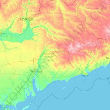
Name: Zaporizhia Oblast topographic map, elevation, terrain.
Location: Zaporizhia Oblast, Ukraine (46.14649 34.13946 48.14493 37.24863)
Average elevation: 75 m
Minimum elevation: -4 m
Maximum elevation: 316 m
Other topographic maps
Click on a map to view its topography, its elevation and its terrain.