
Make a donation
Middleham topographic map
Click on the map to display elevation.
Make a donation
Middleham
The town lies between 400 and 500 feet (120 and 150 m) above ordnance datum. The valley of the River Ure below the town has an altitude of 325 feet (99 m) and the summit of the hill to the south-west of the town of 850 feet (260 m). The parish contains 2,155 acres (872 ha) of land, mostly permanent pasture with about 150 acres (61 ha) arable. The topsoil is mixed. The valley has modern alluvial terraces and gravel deposits, but the subsoil is mainly limestone, intersected here and there by sandstone with plate. There is a known vein of lead in the northern part of the parish. Braithwaite lead mine lies just outside the parish borders.
Make a donation
About this map
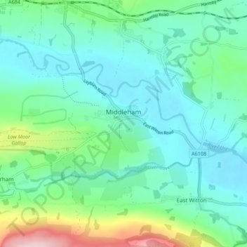
Name: Middleham topographic map, elevation, terrain.
Average elevation: 157 m
Minimum elevation: 95 m
Maximum elevation: 378 m
Make a donation
Other topographic maps
Click on a map to view its topography, its elevation and its terrain.
Scarborough
United Kingdom > England > North Yorkshire
The climate is temperate with mild summers and cool, windy, winters. The hottest months of the year are July and August, with temperatures reaching an average high of 17 °C and falling to 11 °C at night. The average daytime temperatures in January are 4 °C, falling to 1 °C at night. The station's elevation…
Average elevation: 39 m
Make a donation
Make a donation
Make a donation
Make a donation
Make a donation
Make a donation
Make a donation
Make a donation
Make a donation
Make a donation
Make a donation
Make a donation
Bolton Castle
United Kingdom > England > North Yorkshire > Redmire > Castle Bolton
Average elevation: 250 m
Make a donation
Thimbleby & Osmotherly Show field
United Kingdom > England > North Yorkshire > Thimbleby
Average elevation: 152 m
Make a donation
Make a donation
Make a donation
Make a donation
Make a donation
Killinghall
United Kingdom > England > North Yorkshire > Harrogate > Killinghall
Average elevation: 86 m
Make a donation
Make a donation
Make a donation
Make a donation
Arkle Town
United Kingdom > England > North Yorkshire > Richmondshire > Arkle Town
Average elevation: 367 m
Make a donation
Swinithwaite
United Kingdom > England > North Yorkshire > Richmondshire > West Witton > Swinithwaite
Average elevation: 205 m
Make a donation
Make a donation