Geolocate

Healaugh topographic map

Click on the map to display elevation.

About this map

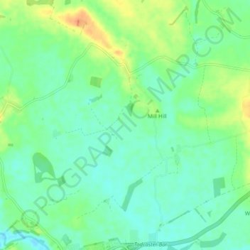
Name: Healaugh topographic map, elevation, terrain.

Location: Healaugh, Selby, North Yorkshire, England, United Kingdom (53.88949 -1.27876 53.93558 -1.21796)

Average elevation: 19 m

Minimum elevation: 7 m

Maximum elevation: 41 m

Other topographic maps

Click on a map to view its topography, its elevation and its terrain.

Ryther

United Kingdom > England > North Yorkshire > Selby

Average elevation: 8 m

Lund

United Kingdom > England > North Yorkshire > Selby

Average elevation: 6 m

Monk Fryston

United Kingdom > England > North Yorkshire > Selby

Average elevation: 14 m

Newton Kyme

United Kingdom > England > North Yorkshire > Selby

Average elevation: 21 m

Brayton

United Kingdom > England > North Yorkshire > Selby

Average elevation: 8 m