
Kronach topographic map
Interactive map
Click on the map to display elevation.
About this map
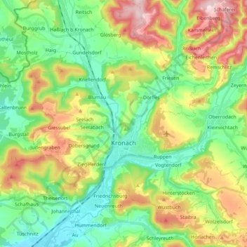
Name: Kronach topographic map, elevation, terrain.
Location: Kronach, Landkreis Kronach, Bayern, 96317, Deutschland (50.19341 11.26470 50.30324 11.41768)
Average elevation: 394 m
Minimum elevation: 287 m
Maximum elevation: 587 m
Other topographic maps
Click on a map to view its topography, its elevation and its terrain.
Steinwiesen
Deutschland > Bayern > Landkreis Kronach
Steinwiesen, Landkreis Kronach, Bayern, 96349, Deutschland
Average elevation: 516 m
Wallenfels
Deutschland > Bayern > Landkreis Kronach
Wallenfels, Landkreis Kronach, Bayern, 96346, Deutschland
Average elevation: 500 m