
Souk El Had topographic map
Interactive map
Click on the map to display elevation.
About this map
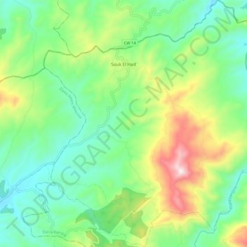
Name: Souk El Had topographic map, elevation, terrain.
Location: Souk El Had, Daïra Ramka, Relizane, Algérie (35.89372 1.21233 35.97881 1.31293)
Average elevation: 447 m
Minimum elevation: 219 m
Maximum elevation: 939 m
Other topographic maps
Click on a map to view its topography, its elevation and its terrain.
Ramka
Algérie > Relizane > Daïra Ramka
Ramka, Daïra Ramka, Relizane, 48024, Algérie
Average elevation: 550 m