
Loy topographic map
Interactive map
Click on the map to display elevation.
About this map
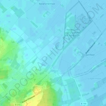
Name: Loy topographic map, elevation, terrain.
Location: Loy, Rastede, Landkreis Ammerland, Niedersachsen, Deutschland (53.22972 8.26104 53.24972 8.28104)
Average elevation: 4 m
Minimum elevation: -4 m
Maximum elevation: 23 m
Other topographic maps
Click on a map to view its topography, its elevation and its terrain.
Leuchtenburg
Deutschland > Niedersachsen > Rastede > Leuchtenburg
Leuchtenburg, Rastede, Landkreis Ammerland, Niedersachsen, 26180, Deutschland
Average elevation: 17 m
Bekhausen
Deutschland > Niedersachsen > Rastede > Bekhausen
Bekhausen, Rastede, Landkreis Ammerland, Niedersachsen, 26180, Deutschland
Average elevation: 7 m
Dorf Nethen
Deutschland > Niedersachsen > Rastede > Dorf Nethen
Dorf Nethen, Rastede, Landkreis Ammerland, Niedersachsen, 26215, Deutschland
Average elevation: 15 m