
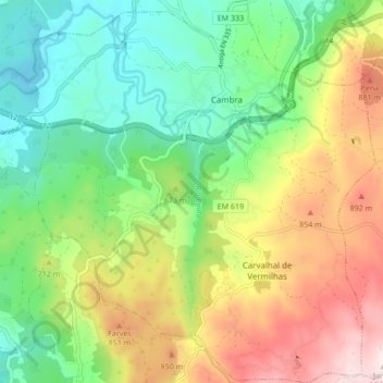
U.F Cambra e Carvalhal de Vermilhas topographic map
Interactive map
Click on the map to display elevation.
About this map
Name: U.F Cambra e Carvalhal de Vermilhas topographic map, elevation, terrain.
Average elevation: 640 m
Minimum elevation: 391 m
Maximum elevation: 1,037 m
Other topographic maps
Click on a map to view its topography, its elevation and its terrain.
Mogueirães
Portugal > Centro > U.F Cambra e Carvalhal de Vermilhas > Mogueirães
Mogueirães, Cambra, U.F Cambra e Carvalhal de Vermilhas, Vouzela, Viseu, Viseu Dão-Lafões, Centro, 3680-170, Portugal
Average elevation: 610 m