
Make a donation
Wittenschwand topographic map
Click on the map to display elevation.
Make a donation
About this map
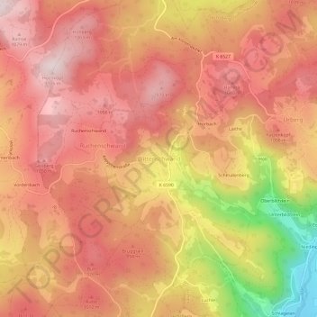
Name: Wittenschwand topographic map, elevation, terrain.
Average elevation: 954 m
Minimum elevation: 648 m
Maximum elevation: 1,102 m
Make a donation
Other topographic maps
Click on a map to view its topography, its elevation and its terrain.
Ühlingen-Birkendorf
Deutschland > Baden-Württemberg > Landkreis Waldshut
Die Flächengemeinde am Südhang des Schwarzwalds liegt zwischen 450 und 1000 Meter Höhe, ihr Gebiet erstreckt sich über vier Täler – der Schwarza im Westen, über die Mettma und die Schlücht bis hin zur Steina im Osten (Ausdehnung Nord-Süd-Richtung 10 km, West-Ost-Richtung 15 km).
Average elevation: 708 m
Wutach
Deutschland > Baden-Württemberg > Landkreis Waldshut
Vor Lauchringen schwenkt die Wutach wiederum in die Laufrichtung eines Nebenbachs ein, nun in die des in breitem Tal aus dem Klettgau kommenden Klingengrabens. In Unterlauchringen bildete die Wutach einen der größten Flusswasserfälle Deutschlands, wegen dessen Wasserkraft hier die Lauffenmühle entstand,…
Average elevation: 627 m
Bonndorf im Schwarzwald
Deutschland > Baden-Württemberg > Landkreis Waldshut
Bonndorf liegt in Südwestdeutschland in 600 m bis 1050 m Höhe im Nordosten des Landkreises Waldshut. Die Stadt liegt südlich der Wutach, zu der sie über die Wutachschlucht im Ortsteil Boll sowie die Lotenbachklamm Zugang hat, etwa 18 Kilometer von der Schweizer Grenze (Stühlingen/Schleitheim) entfernt.…
Average elevation: 798 m
Make a donation
Bad Säckingen
Deutschland > Baden-Württemberg > Landkreis Waldshut
Im Gewann Wolfsrütte befindet sich eine Gruppe von Mittelwaldeichen. Vier an einem Waldweg stehende besonders mächtige Exemplare sind unter der Bezeichnung Wolfseichen bekannt. Drei dieser Bäume sind als Naturdenkmale ausgewiesen. Die größte der Wolfseichen hat einen Brusthöhendurchmesser von 1,80 Metern…
Average elevation: 438 m
Make a donation
St. Blasien
Deutschland > Baden-Württemberg > Landkreis Waldshut
Nach einer Brandkatastrophe 1768 errichtete der Architekt Pierre Michel d’Ixnard (1768–1781) eine neue Abteikirche im Zopfstil. Der Kuppelbau ist mit 36 Metern im Durchmesser und 62 Metern Höhe der drittgrößte seiner Art in Europa.
Average elevation: 944 m
Stühlingen
Deutschland > Baden-Württemberg > Landkreis Waldshut
Der Luftkurort Stühlingen liegt an der Wutach am Südrand des Schwarzwaldes in 449 bis 850 Meter Höhe, direkt an der Grenze zur Schweiz nahe der Gemeinde Schleitheim. Stühlingen liegt im Naturpark Südschwarzwald.
Average elevation: 652 m
Wehr
Deutschland > Baden-Württemberg > Landkreis Waldshut
Wehr ist westwärts über die Eichener Höhe mit Schopfheim und südwärts mit Bad Säckingen verbunden. Nordostwärts wehraaufwärts gelangt man zum Wehrastausee und weiter durch das hier tief eingeschnittene und wilde Wehratal nach Todtmoos.
Average elevation: 551 m
Dachsberg (Südschwarzwald)
Deutschland > Baden-Württemberg > Landkreis Waldshut
Der staatlich anerkannte Erholungsort Dachsberg liegt im Hotzenwald im Südschwarzwald auf der Westseite des Albtals in 543 bis 1105 Meter Höhe. Die Dachsberglandschaft ist gekennzeichnet durch verschieden große Hochebenen, die terrassenartig gestuft nach Süden hin abfallen. Die meisten Ortsteile liegen auf…
Average elevation: 872 m
Make a donation
Todtmoos
Deutschland > Baden-Württemberg > Landkreis Waldshut
Todtmoos ist eine Gemeinde im Landkreis Waldshut in Baden-Württemberg. Der heilklimatische Kurort liegt im Südschwarzwald auf über 700 Meter Höhe.
Average elevation: 977 m
Grafenhausen
Deutschland > Baden-Württemberg > Landkreis Waldshut
„Zwischen dem tiefsten Punkt der Gemarkung im Erlenbachtal (ungefähr 760 m) und dem höchsten Punkt der Gemeinde beim Faulenfürster Eck (ca. 1100 m)“ kennzeichnen zuerst Laub- und Mischwald die Landschaft, ab 1000 Meter Nadelwald. Etwa 62 Prozent des Gemeindegebietes sind bewaldet. Das Klima bestimmt…
Average elevation: 898 m
Herrischried
Deutschland > Baden-Württemberg > Landkreis Waldshut
Auf dem nordöstlich des Kerndorfes liegenden Gugel auf der Gemarkung des Ortsteils Wehrhalden steht auf 996 Meter Höhe der Gugelturm der 30 Meter in die Höhe ragt und auf 16 Metern eine Aussichtsplattform hat. Der erste – wesentlich kleinere – Gugelturm wurde 1930 eingeweiht und 1971 von britischen…
Average elevation: 883 m
Laufenburg (Baden)
Deutschland > Baden-Württemberg > Landkreis Waldshut
Ein weiteres bedeutendes Gewerbe bildeten die „Laufenknechte“, die gegen gutes Geld oberhalb der Stromschnellen Schiffe entluden, die Waren auf Karren packten und die leeren Boote an Seilen durch das tosende Wasser führten. Auch Flöße wurden von ihnen aufgebunden, die Stämme einzeln durch den…
Average elevation: 479 m
Make a donation
Im Hüttlebuck
Deutschland > Baden-Württemberg > Landkreis Waldshut > St. Blasien
Average elevation: 885 m
Eschbach
Deutschland > Baden-Württemberg > Landkreis Waldshut
Eschbach liegt im Südschwarzwald am Übergang zum Hochrhein, im Tal des Liederbach, eines direkten Rheinzuflusses. Die Gemarkung erstreckt sich über den mittleren Teil des von Norden nach Süden verlaufenden Liederbach-Tals bis auf die Höhen der Bergrücken im Osten und Westen. Der Ort selbst liegt im Tal,…
Average elevation: 526 m
Vogtsberg
Deutschland > Baden-Württemberg > Landkreis Waldshut > Bonndorf im Schwarzwald > Gündelwangen
Average elevation: 835 m
Make a donation
Höchenschwand
Deutschland > Baden-Württemberg > Landkreis Waldshut
Ab 1950 wird Höchenschwand als „Kurort der natürlichen Höhensonne“, insbesondere das Kurhaus Höchenschwand und das Augensanatorium Sonnenhof als Privatheilanstalten, zu einem sehr bekannten Kurort weit über die Landesgrenzen hinaus.
Average elevation: 843 m
Menzenschwand
Deutschland > Baden-Württemberg > Landkreis Waldshut > St. Blasien
Average elevation: 1,083 m
Make a donation
Murg
Deutschland > Baden-Württemberg > Landkreis Waldshut
Murg liegt direkt am Hochrhein zwischen 290 und 803 Meter Höhe.
Average elevation: 520 m
Wutöschingen
Deutschland > Baden-Württemberg > Landkreis Waldshut
Fast ebenso bedeutsam in der Region ist die keltische Höhenburg auf dem Semberg bei Schwerzen, da hier noch Wallstrukturen festgestellt werden können. In der Nähe liegt auch das Schloßbückle, dessen Zugehörigkeit schwer feststellbar ist – eine ungewöhnliche Annahme ist, dass es sich um eine römische…
Average elevation: 459 m
Make a donation
Wutachschlucht
Deutschland > Baden-Württemberg > Landkreis Waldshut > Bonndorf im Schwarzwald
Average elevation: 792 m
Make a donation
Riedern am Wald
Deutschland > Baden-Württemberg > Landkreis Waldshut
Riedern liegt auf der Südostabdachung des Südschwarzwaldes im Hotzenwald. Der Grundgebirgssockel lagert hier bereits so tief, dass sich auf ihm um Riedern Schichten des Deckgebirges erhalten haben, die weiter westlich auf den Höhen des Schwarzwaldes weitgehend der Abtragung anheimgefallen sind. Diese…
Average elevation: 680 m
Brenden
Deutschland > Baden-Württemberg > Landkreis Waldshut
Der Ortsteil Brenden liegt auf dem Brendener Berg oberhalb von Berau und unterhalb von Staufen zwischen den Tälern der Mettma und der Schwarza. Vom „Rappenfelsen“ und dem „Großen Felsen“ an der Talkante zur Schwarza bietet sich ein weiter Landschaftsblick. Zwei Brendener Bürger sind Wegpaten zum…
Average elevation: 833 m
Make a donation
79872
Deutschland > Baden-Württemberg > Landkreis Waldshut > Innerlehen > Riggenbach
Average elevation: 1,037 m
Make a donation
Birkendorf
Deutschland > Baden-Württemberg > Landkreis Waldshut
„Am 20. Juni wurde der Kugelwaldpfad eröffnet – der Höhepunkt des Jahres. Seither pilgerten Menschenscharen nach Birkendorf und ließen sich von der neuen Attraktion oberhalb des Naturena Badesees begeistern.“ Das alte Birkendorfer Waldbad am Schlüchtsee wurde 2002 mit zahlreichen Wasser-Anlagen…
Average elevation: 786 m
Weilheim
Deutschland > Baden-Württemberg > Landkreis Waldshut
Ein Grabhügel im Gewann Dörnen [bei Nöggenschwiel] und ein Bronzedolch beweisen, dass schon während der Bronzezeit (2000 bis 1000 v. Chr.) dieses Höhengebiet bewohnt war. Aus der Zeit der Römerherrschaft (1. bis 4. Jahrh. n. Chr.) stammen wohl die auf einen römischen Wachtturm hinweisenden Baureste, der…
Average elevation: 607 m
Make a donation
79737
Deutschland > Baden-Württemberg > Landkreis Waldshut > Herrischried > Rütte
Average elevation: 876 m
Schmitzingen
Deutschland > Baden-Württemberg > Landkreis Waldshut
Schmitzingen liegt im Südschwarzwald am Übergang zum Hochrhein, im Tal des Seltenbach, eines direkten Rheinzuflusses. Die Ortschaft liegt auf dem Gebiet der Ortschaft Gaiß-Waldkirch, die sich über die obere Hälfte des Seltenbachtales bis auf die Bergrücken im Osten und in das Liederbach-Tal im Westen…
Average elevation: 614 m
Make a donation
Ühlingen
Deutschland > Baden-Württemberg > Landkreis Waldshut
Der im Juli 2021 offiziell eröffnete Mehrgenerationenpark war ein Wunsch des Ortschaftsrates Ühlingen. Er ersetzt den ehemaligen Kurpark, der als Grünfläche „in Zeiten des Krieges von der Gemeinde in Gartenzellen aufgeteilt und den Bürgern, die kein Eigentum hatten, zur Verfügung gestellt wurden.“…
Average elevation: 693 m
Waldshut-Tiengen
Deutschland > Baden-Württemberg > Landkreis Waldshut
Die Panzerbrigade bezog Stellung auf der Gemarkung im Linkeren und im Hüller. Für die höheren Dienstgrade mussten Zimmer in der Stadt bereitgestellt werden. Der Weitermarsch erfolgte über die Zeppelinstraße – (heutige) Bundesstraße nach Unterlauchringen.
Average elevation: 553 m
Make a donation
Schwarza-Talsperre
Deutschland > Baden-Württemberg > Landkreis Waldshut > Schönenbach
Average elevation: 870 m
Küssaburg
Deutschland > Baden-Württemberg > Landkreis Waldshut > Küssaberg > Bechtersbohl
Die Höhenburg ist historisches Baudenkmal am Hochrhein und ein Wahrzeichen des Landkreises. In den Anfangsjahren der Wertschätzung von Archäologie im 19. Jh. schützte ein erstes Gesetz die Erhaltung und Freilegung der Burgruine (1855), die heute ein beliebtes Ausflugsziel in der Region ist. Die…
Average elevation: 456 m
Make a donation
Schlücht
Deutschland > Baden-Württemberg > Landkreis Waldshut
Am Weiler Riedersteg endet die breite Talsohle, und die zunächst niedrigen Uferhänge werden allmählich höher und rasch felsiger. Ab der Einmündung der Mettma hat das Tal Schluchtcharakter.
Average elevation: 669 m
Schlüchtsee
Deutschland > Baden-Württemberg > Landkreis Waldshut > Grafenhausen
Average elevation: 938 m
Wutach
Deutschland > Baden-Württemberg > Landkreis Waldshut
Vor Lauchringen schwenkt die Wutach wiederum in die Laufrichtung eines Nebenbachs ein, nun in die des in breitem Tal aus dem Klettgau kommenden Klingengrabens. In Unterlauchringen bildete die Wutach einen der größten Flusswasserfälle Deutschlands, wegen dessen Wasserkraft hier die Lauffenmühle entstand,…
Average elevation: 627 m
Make a donation
Laufenburg (Baden)
Deutschland > Baden-Württemberg > Landkreis Waldshut
Ein weiteres bedeutendes Gewerbe bildeten die „Laufenknechte“, die gegen gutes Geld oberhalb der Stromschnellen Schiffe entluden, die Waren auf Karren packten und die leeren Boote an Seilen durch das tosende Wasser führten. Auch Flöße wurden von ihnen aufgebunden, die Stämme einzeln durch den…
Average elevation: 479 m
Wehr
Deutschland > Baden-Württemberg > Landkreis Waldshut
Wehr ist westwärts über die Eichener Höhe mit Schopfheim und südwärts mit Bad Säckingen verbunden. Nordostwärts wehraaufwärts gelangt man zum Wehrastausee und weiter durch das hier tief eingeschnittene und wilde Wehratal nach Todtmoos.
Average elevation: 551 m
Make a donation
Herrischried
Deutschland > Baden-Württemberg > Landkreis Waldshut
Auf dem nordöstlich des Kerndorfes liegenden Gugel auf der Gemarkung des Ortsteils Wehrhalden steht auf 996 Meter Höhe der Gugelturm der 30 Meter in die Höhe ragt und auf 16 Metern eine Aussichtsplattform hat. Der erste – wesentlich kleinere – Gugelturm wurde 1930 eingeweiht und 1971 von britischen…
Average elevation: 883 m
Weilheim
Deutschland > Baden-Württemberg > Landkreis Waldshut
Ein Grabhügel im Gewann Dörnen [bei Nöggenschwiel] und ein Bronzedolch beweisen, dass schon während der Bronzezeit (2000 bis 1000 v. Chr.) dieses Höhengebiet bewohnt war. Aus der Zeit der Römerherrschaft (1. bis 4. Jahrh. n. Chr.) stammen wohl die auf einen römischen Wachtturm hinweisenden Baureste, der…
Average elevation: 607 m
Make a donation
St. Blasien
Deutschland > Baden-Württemberg > Landkreis Waldshut
Nach einer Brandkatastrophe 1768 errichtete der Architekt Pierre Michel d’Ixnard (1768–1781) eine neue Abteikirche im Zopfstil. Der Kuppelbau ist mit 36 Metern im Durchmesser und 62 Metern Höhe der drittgrößte seiner Art in Europa.
Average elevation: 944 m
Laufenburg (Baden)
Deutschland > Baden-Württemberg > Landkreis Waldshut
Ein weiteres bedeutendes Gewerbe bildeten die „Laufenknechte“, die gegen gutes Geld oberhalb der Stromschnellen Schiffe entluden, die Waren auf Karren packten und die leeren Boote an Seilen durch das tosende Wasser führten. Auch Flöße wurden von ihnen aufgebunden, die Stämme einzeln durch den…
Average elevation: 479 m
Todtmoos
Deutschland > Baden-Württemberg > Landkreis Waldshut
Todtmoos ist eine Gemeinde im Landkreis Waldshut in Baden-Württemberg. Der heilklimatische Kurort liegt im Südschwarzwald auf über 700 Meter Höhe.
Average elevation: 977 m
Dachsberg (Südschwarzwald)
Deutschland > Baden-Württemberg > Landkreis Waldshut
Der staatlich anerkannte Erholungsort Dachsberg liegt im Hotzenwald im Südschwarzwald auf der Westseite des Albtals in 543 bis 1105 Meter Höhe. Die Dachsberglandschaft ist gekennzeichnet durch verschieden große Hochebenen, die terrassenartig gestuft nach Süden hin abfallen. Die meisten Ortsteile liegen auf…
Average elevation: 872 m
Make a donation
Lauchringen
Deutschland > Baden-Württemberg > Landkreis Waldshut
Oberlauchringen ist weitaus älter; hier sind Spuren aus der Frühgeschichte zu vermerken, während Unterlauchringen als Siedlung auf einer „steinigen Anhöhe“ in einer Schleife der Wutach erst ab dem 17. Jahrhundert dokumentiert ist und noch 1806 dort nur ein „kleines Dorf“ erwähnt wird.
Average elevation: 386 m
Mettenberg
Deutschland > Baden-Württemberg > Landkreis Waldshut
„Zwischen dem tiefsten Punkt der Gemarkung im Erlenbachtal (ungefähr 760 m) und dem höchsten Punkt der Gemeinde beim Faulenfürster Eck (ca. 1100 m)“ kennzeichnen zuerst Laub- und Mischwald die Landschaft, ab 1000 Meter Nadelwald. Etwa 62 Prozent des Gemeindegebietes sind bewaldet. Das Klima bestimmt…
Average elevation: 841 m
Make a donation
Bonndorf im Schwarzwald
Deutschland > Baden-Württemberg > Landkreis Waldshut
Bonndorf liegt in Südwestdeutschland in 600 m bis 1050 m Höhe im Nordosten des Landkreises Waldshut rund 18 Kilometer nördlich der Schweizer Grenze (Stühlingen/Schleitheim). Die Stadt liegt südlich der Wutach, zu der sie über die Wutachschlucht im Ortsteil Boll sowie über die Lotenbachklamm Zugang hat.…
Average elevation: 798 m
Todtmoos
Deutschland > Baden-Württemberg > Landkreis Waldshut
Todtmoos ist eine Gemeinde im Landkreis Waldshut in Baden-Württemberg. Der heilklimatische Kurort liegt im Südschwarzwald auf über 700 Meter Höhe.
Average elevation: 977 m
Todtmoos
Deutschland > Baden-Württemberg > Landkreis Waldshut
Todtmoos ist eine Gemeinde im Landkreis Waldshut in Baden-Württemberg. Der heilklimatische Kurort liegt im Südschwarzwald auf über 700 Meter Höhe.
Average elevation: 977 m
Make a donation
Lauchringen
Deutschland > Baden-Württemberg > Landkreis Waldshut
Oberlauchringen ist weitaus älter; hier sind Spuren aus der Frühgeschichte zu vermerken, während Unterlauchringen als Siedlung auf einer „steinigen Anhöhe“ in einer Schleife der Wutach erst ab dem 17. Jahrhundert dokumentiert ist und noch 1806 dort nur ein „kleines Dorf“ erwähnt wird.
Average elevation: 386 m
Eggingen
Deutschland > Baden-Württemberg > Landkreis Waldshut
Die Gemeinde Eggingen liegt zwischen Südschwarzwald und Klettgau direkt an der Grenze zum Schweizer Kanton Schaffhausen auf 430 m bis 680 m Meereshöhe.
Average elevation: 535 m