
Wye topographic map
Interactive map
Click on the map to display elevation.
About this map
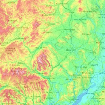
Name: Wye topographic map, elevation, terrain.
Location: Wye, England, United Kingdom (51.59470 -3.76468 52.46891 -2.55976)
Average elevation: 207 m
Minimum elevation: 0 m
Maximum elevation: 834 m
The River Wye is protected by two Sites of Special Scientific Interest, one covering the Upper Wye (Gwy Uchaf) above Hay-on-Wye, and one covering the Lower Wye (Gwy Isaf) downstream to Chepstow. The criteria for inclusion of the river as an SSSI include geology, topography, flora, mammals, invertebrates, fish and birdlife, as the river and its tributaries constitute a large linear ecosystem. The Lower Wye SSSI is itself divided into seven units of assessment set by Natural England, and administrative responsibilities are shared between the councils of Powys, Herefordshire, Gloucestershire, and Monmouthshire. The Wye abuts a range of other SSSIs in England and Wales, including the Upper Wye Gorge and Lower Wye Gorge.
Other topographic maps
Click on a map to view its topography, its elevation and its terrain.
London
United Kingdom > England > London
London, Greater London, England, SW1A 2DX, United Kingdom
Average elevation: 42 m
Sheffield
Sheffield, South Yorkshire, England, United Kingdom
Average elevation: 168 m
London
London, Greater London, England, United Kingdom
Average elevation: 66 m
Norwich
United Kingdom > England > Norfolk
Norwich, Norfolk, England, United Kingdom
Average elevation: 28 m
Northamptonshire
Northamptonshire, England, United Kingdom
Average elevation: 97 m
Lincolnshire
Lincolnshire, East Midlands, England, United Kingdom
Average elevation: 28 m
Liverpool
Liverpool, Liverpool City Region, England, United Kingdom
Average elevation: 26 m
Bristol
United Kingdom > England > City of Bristol
Bristol, City of Bristol, West of England, England, United Kingdom
Average elevation: 55 m
Keswick
United Kingdom > England > Keswick
Keswick, Cumbria, North West England, England, CA12 5JF, United Kingdom
Average elevation: 223 m
Bedford
United Kingdom > England > Bedford
Bedford, England, MK40 1SU, United Kingdom
Average elevation: 37 m
Reading
United Kingdom > England > West Berkshire > Reading
Reading, West Berkshire, South East England, England, RG1 1DA, United Kingdom
Average elevation: 56 m
City of London
United Kingdom > England > City of London > City of London
City of London, England, EC2V 5AE, United Kingdom
Average elevation: 42 m
Milton Keynes
United Kingdom > England > Milton Keynes > Milton Keynes
Milton Keynes, South East England, England, MK9 3AF, United Kingdom
Average elevation: 81 m
East of England
East of England, England, United Kingdom
Average elevation: 39 m
Warminster
United Kingdom > England > Wiltshire
Warminster, Wiltshire, England, United Kingdom
Average elevation: 143 m
Cambridge
United Kingdom > England > Cambridge
Cambridge, Cambridgeshire, East of England, England, United Kingdom
Average elevation: 18 m
Bournemouth
United Kingdom > England > Bournemouth, Christchurch and Poole > Wick
Bournemouth, Wick, Bournemouth, Christchurch and Poole, England, United Kingdom
Average elevation: 17 m
Nottingham
United Kingdom > England > Nottinghamshire
Nottingham, England, United Kingdom
Average elevation: 56 m
Lake District National Park
Lake District National Park, England, United Kingdom
Average elevation: 206 m
Keysoe
United Kingdom > England > Bedford
Keysoe, Bedford, England, MK44 2HS, United Kingdom
Average elevation: 58 m
Richmond Park
United Kingdom > England > London
Richmond Park, London Borough of Richmond upon Thames, London, Greater London, England, United Kingdom
Average elevation: 26 m
North Yorkshire
North Yorkshire, Yorkshire and the Humber, England, United Kingdom
Average elevation: 153 m
Somerset
Somerset, South West England, England, United Kingdom
Average elevation: 87 m
Welwyn Garden City
United Kingdom > England > Hertfordshire > Welwyn Hatfield
Welwyn Garden City, Welwyn Hatfield, Hertfordshire, England, AL8 6TP, United Kingdom
Average elevation: 89 m
Bexhill-on-Sea
United Kingdom > England > East Sussex > Rother
Bexhill-on-Sea, Rother, East Sussex, England, TN39 3JX, United Kingdom
Average elevation: 13 m
Maidenhead
United Kingdom > England > Royal Borough of Windsor and Maidenhead
Maidenhead, Royal Borough of Windsor and Maidenhead, England, SL6 1QB, United Kingdom
Average elevation: 41 m
Portsmouth
United Kingdom > England > Hampshire > Portsmouth
Portsmouth, Hampshire, South East England, England, PO1 5QH, United Kingdom
Average elevation: 28 m
Basingstoke
United Kingdom > England > Hampshire > Basingstoke and Deane
Basingstoke, Basingstoke and Deane, Hampshire, England, United Kingdom
Average elevation: 110 m
Oxford
United Kingdom > England > Oxfordshire
Oxford, Oxfordshire, England, United Kingdom
Average elevation: 81 m
Lincoln
United Kingdom > England > Lincolnshire
Lincoln, Lincolnshire, England, United Kingdom
Average elevation: 29 m
Chesterfield
United Kingdom > England > Derbyshire
Chesterfield, Derbyshire, England, United Kingdom
Average elevation: 127 m
Coventry
Coventry, West Midlands Combined Authority, England, United Kingdom
Average elevation: 99 m
Birmingham
Birmingham, West Midlands Combined Authority, England, United Kingdom
Average elevation: 138 m
Brighton
United Kingdom > England > Brighton and Hove
Brighton, Brighton and Hove, England, United Kingdom
Average elevation: 64 m
Marystow
United Kingdom > England > Devon > West Devon > Chillaton
Marystow, Chillaton, West Devon, Devon, England, United Kingdom
Average elevation: 128 m
Peak District National Park
United Kingdom > England > Derbyshire
Peak District National Park, Derbyshire, South Yorkshire, England, United Kingdom
Average elevation: 225 m
Leighton Buzzard
United Kingdom > England > Central Bedfordshire
Leighton Buzzard, Central Bedfordshire, England, LU7 1EE, United Kingdom
Average elevation: 103 m
Hitchin
United Kingdom > England > Hertfordshire > North Hertfordshire
Hitchin, North Hertfordshire, Hertfordshire, England, SG5 1BB, United Kingdom
Average elevation: 91 m
Barrow-in-Furness
United Kingdom > England > Westmorland and Furness > Stank
Barrow-in-Furness, Stank, Westmorland and Furness, England, United Kingdom
Average elevation: 22 m