
Thank you for supporting this site ❤️
Make a donation
Make a donation
L'Oignon topographic map
Click on the map to display elevation.
Thank you for supporting this site ❤️
Make a donation
Make a donation
About this map
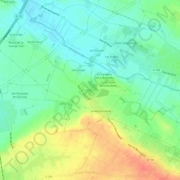
Name: L'Oignon topographic map, elevation, terrain.
Average elevation: 43 m
Minimum elevation: 24 m
Maximum elevation: 74 m
Thank you for supporting this site ❤️
Make a donation
Make a donation
Other topographic maps
Click on a map to view its topography, its elevation and its terrain.
79230
France > Nouvelle-Aquitaine > Deux-Sèvres > Saint-Martin-de-Bernegoue > La Fontaine de la Rochelle
Average elevation: 57 m