
Thank you for supporting this site ❤️
Make a donation
Make a donation
Puerto Libre topographic map
Click on the map to display elevation.
Thank you for supporting this site ❤️
Make a donation
Make a donation
About this map
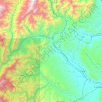
Name: Puerto Libre topographic map, elevation, terrain.
Location: Puerto Libre, Gonzalo Pizarro, Sucumbíos, Ecuador (-0.00254 -77.74399 0.37514 -77.35040)
Average elevation: 1,214 m
Minimum elevation: 404 m
Maximum elevation: 3,426 m
Thank you for supporting this site ❤️
Make a donation
Make a donation
Other topographic maps
Click on a map to view its topography, its elevation and its terrain.