
Make a donation
Kalka topographic map
Click on the map to display elevation.
Make a donation
About this map
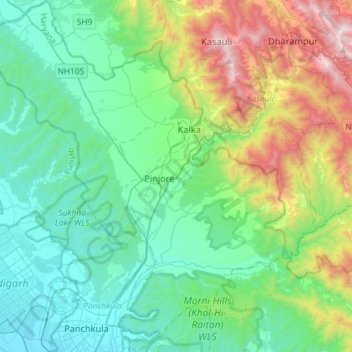
Name: Kalka topographic map, elevation, terrain.
Location: Kalka, Panchkula District, Haryana, India (30.68062 76.77596 30.92877 77.02075)
Average elevation: 723 m
Minimum elevation: 315 m
Maximum elevation: 1,971 m
Make a donation
Other topographic maps
Click on a map to view its topography, its elevation and its terrain.
Make a donation
Make a donation
Make a donation
Hisar
Hisar is located at 29°05′N 75°26′E / 29.09°N 75.43°E / 29.09; 75.43 in western Haryana. It has an average elevation of 215 m (705 ft) above mean sea level. The region is part of the alluvial Ghaggar-Yamuna plain and its southern and western portions mark a gradual transition to the desert.…
Average elevation: 213 m
Make a donation
Make a donation
Make a donation
Make a donation
Surajkund
In the Aravalli hill ranges, which spreads over Delhi and Haryana, where the Surajkund and the Anagpur Dam are located, ancient Stone Age relics have been revealed. The Aravallis, which strike out in two directions from Delhi exhibits a topography of low and rugged hills. The stratigraphy in the area is…
Average elevation: 230 m
Make a donation
Make a donation
Make a donation
Narnaul
Narnaul is located at 28°02′N 76°07′E / 28.04°N 76.11°E / 28.04; 76.11. It has an average elevation of 300 meters (977 feet). The district is rich in mineral resources such as iron ore, copper ore, beryl, tourmaline, muscovite, biotite, albite, calcite, and quartz.
Average elevation: 318 m
Make a donation