
Make a donation
Ramsgill topographic map
Click on the map to display elevation.
Make a donation
About this map
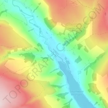
Name: Ramsgill topographic map, elevation, terrain.
Average elevation: 260 m
Minimum elevation: 133 m
Maximum elevation: 437 m
Make a donation
Other topographic maps
Click on a map to view its topography, its elevation and its terrain.
North York Moors National Park
United Kingdom > England > North Yorkshire
As part of the United Kingdom, the North York Moors area generally has warm summers and relatively mild winters. Weather conditions vary from day to day as well as from season to season. The latitude of the area means that it is influenced by predominantly westerly winds with depressions and their associated…
Average elevation: 110 m
Make a donation
Harrogate
United Kingdom > England > North Yorkshire
Harrogate is situated on the edge of the Yorkshire Dales, with the Vale of York to the east and the upland Yorkshire Dales to the west and north-west. It has a dry and mild climate, typical of places in the rain shadow of the Pennines. It is on the A59 from Skipton to York. At an altitude of between 100 and…
Average elevation: 131 m
Scarborough
United Kingdom > England > North Yorkshire
The climate is temperate with mild summers and cool, windy, winters. The hottest months of the year are July and August, with temperatures reaching an average high of 17 °C and falling to 11 °C at night. The average daytime temperatures in January are 4 °C, falling to 1 °C at night. The station's elevation…
Average elevation: 50 m
Make a donation
Make a donation
Make a donation
Hovingham
United Kingdom > England > North Yorkshire
The nearest settlements are Slingsby 1.75 miles (2.82 km) to the east; Stonegrave 1.6 miles (2.6 km) to the north; Cawton 1.9 miles (3.1 km) to the north-west; Coulton 2.2 miles (3.5 km) to the west south-west and Scackleton 2.1 miles (3.4 km) to the south-west. The village lies at an elevation of 215 feet (66…
Average elevation: 61 m
Make a donation
Make a donation
Make a donation
Make a donation
Yorkshire Water Flood Alleviation Scheme
United Kingdom > England > North Yorkshire > Filey > Gristhorpe
Average elevation: 36 m
Malham
United Kingdom > England > North Yorkshire
Malham has an Oceanic climate, but is generally colder and wetter than most settlements in Britain. It has a relatively low altitude of around 200 metres, but is partly surrounded by fells. This exposed position means the temperature range is limited, due to little pooling of cold air. Extremes of temperature…
Average elevation: 362 m
Make a donation
Levisham Moor
United Kingdom > England > North Yorkshire > Newton upon Rawcliffe
Average elevation: 188 m
Make a donation
Newton-le-Willows
United Kingdom > England > North Yorkshire > Newton le Willows
Average elevation: 100 m
Make a donation
Make a donation
Make a donation
Make a donation
Make a donation
Make a donation
Farlington
United Kingdom > England > North Yorkshire
The village is at an elevation of 123 feet (37 m) above sea level at its highest point. The nearest settlements are Stillington 2 miles (3.2 km) to the west; Sheriff Hutton 2.3 miles (3.7 km) to the east-south-east; Brandsby-cum-Stearsby 2.6 miles (4.2 km) to the north and Sutton-on-the-Forest 2.71 miles (4.36…
Average elevation: 40 m
Make a donation
Thornton-le-Street
United Kingdom > England > North Yorkshire
The village is located between the west bank of the Cod Beck and the A168 road between Thirsk and Northallerton. Within a radius of 2.5 miles (4 km) can be found the settlements of Thornton-le-Moor, Borrowby, Knayton, Upsall, South Kilvington, Newsham and South Otterington. The mean elevation in the village is…
Average elevation: 50 m
Make a donation
River Derwent
United Kingdom > England > North Yorkshire
Rainfall and climate conditions vary slightly across the Derwent catchment area due to the topography. Annual rainfall ranges from averages of 600 millimetres (24 in) at Barmby Barrage to over 1,100 millimetres (43 in) at its source on the North York Moors.
Average elevation: 66 m
Make a donation
Make a donation
Make a donation
Make a donation
Bolton Castle
United Kingdom > England > North Yorkshire > Redmire > Castle Bolton
Average elevation: 250 m
Make a donation
Make a donation
Thimbleby & Osmotherly Show field
United Kingdom > England > North Yorkshire > Thimbleby
Average elevation: 152 m
Make a donation