
Make a donation
Saigon topographic map
Click on the map to display elevation.
Make a donation
Saigon
The city is located in the south-eastern region of Vietnam, 1,760 km (1,090 mi) south of Hanoi. The average elevation is 5 m (16 ft) above sea level for the city centre and 16 m (52 ft) for the suburb areas. It borders Tây Ninh Province and Bình Dương Province to the north, Đồng Nai Province and Bà Rịa–Vũng Tàu province to the east, Long An Province to the west, Tiền Giang Province and East Sea to the south with a coast 15 km (9 mi) long. The city covers an area of 2,095 km2 (809 sq mi or 0.63% of the surface of Vietnam), extending up to Củ Chi District (12 mi or 19 km from the Cambodian border) and down to Cần Giờ on the Eastern Sea. The distance from the northernmost point (Phú Mỹ Hưng Commune, Củ Chi District) to the southernmost one (Long Hòa Commune, Cần Giờ District) is 102 km (63 mi), and from the easternmost point (Long Bình ward, District Nine) to the westernmost one (Bình Chánh Commune, Bình Chánh District) is 47 km (29 mi). Due to its location on the Mekong Delta, the city is fringed by tidal flats that have been heavily modified for agriculture.
Make a donation
About this map
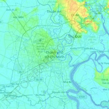
Name: Saigon topographic map, elevation, terrain.
Location: Saigon, Ho Chi Minh City, 71006, Vietnam (10.61641 106.54116 10.93641 106.86116)
Average elevation: 6 m
Minimum elevation: -15 m
Maximum elevation: 57 m
Make a donation
Other topographic maps
Click on a map to view its topography, its elevation and its terrain.
Make a donation
Du Gia - Dong Van Karst Plateau National Park
Vietnam > Hà Giang Province > Bắc Mê District
Average elevation: 818 m
Make a donation
Make a donation
Lào Cai Province
There are ten major soil groups under 30 categories in the province, under ten land groups. The land groups are: The Alluvial group (1.47% of the land area) along the Red River is good for growing food crops and trees; the Oxisol type which occupies 40% of land area has generally reddish brown soil, below…
Average elevation: 791 m
Hồ Đá Bàng
Vietnam > Bà Rịa - Vũng Tàu Province > Chau Duc District > Da Bac Commune
Average elevation: 45 m
Make a donation
Make a donation
Hà Giang Province
The provincial capital, also called Hà Giang, is connected by Highway 2 and is 320 km away from Hanoi. The border crossing is at Thanh Thủy, 25 km from the provincial capital. It is one of the poorest provinces of Vietnam as it has mountainous topography with the least potential for agricultural development.
Average elevation: 839 m
Make a donation
Cao Bằng Province
The Peninsular valley of Cao Bằng province is formed between the Bằng Giang and Hien rivers. The two rivers confluence to the northwest of the town. In the war with China the town was damaged in 1979 and has been since rebuilt. The market in Cao Bằng town is believed to be the largest in Vietnam. Cao…
Average elevation: 638 m
Make a donation
Hue City
Vietnam > Thừa Thiên Huế Province
Located near Truong Son mountain range, Hue city is a plain area in the lower reaches of the Perfume and Bo rivers, with an average altitude of 3–4 m above sea level and often flooded when the river's headwaters Huong has medium and large rainfall. This plain area is relatively flat, although there are…
Average elevation: 24 m
Make a donation
Quảng Bình Province
Coordinates 16°55’ to 18°05’ North and 105°37’ to 107°00’ East. It borders Hà Tĩnh province on the north with the Ngang mountain pass as the natural frontier, Quảng Trị province to the south, Laos to the west, and faces the Dong Sea to the east. The narrowest part from east (seaside) to west…
Average elevation: 210 m
Bac Kan Province
The province is in the northeast midland mountainous area of Vietnam. Its terrain has the highest altitude among the 11 provinces of the region. Forest area dominates more than 95% of the province. The remainder is available for agricultural and other uses. Due to this rugged and forested topography,…
Average elevation: 458 m
Make a donation
Tuyen Quang Province
The province has widely varying topography covering high mountains deep valleys; the dominant elevation of the province is in the range 200–600 metres (660–1,970 ft). The province is in the foothills of the Northern Highlands, which forms a broad crescent around the Tonkin Delta; its southern part has…
Average elevation: 324 m
Yen Bai City
The topography is steep, rising from east to west and from south to north. The average elevation is about 600 metres (2,000 ft) above sea level and can be divided into two regions: low-lying regions on the left bank of the Red River basin and the high right bank of the Red River and in the plateau between the…
Average elevation: 72 m
Make a donation
Lạng Sơn Province
The province is set in karstic limestone mountains and valleys. Mountains and forests comprise 80% of the province's area. The province measures approximately 123 kilometres from north to south and 126 kilometres from west to east. The average altitude of the province is 252 metres (827 ft) above sea level.…
Average elevation: 290 m
Make a donation
Tien Giang province
Tiền Giang province has flat terrain with a slope below 1%, and the altitude varying from 0–1.6 metres (0.0–5.2 ft) in comparison with the sea level. The whole province area is in the lower section of Mekong River. Its current terrain surface and land was created by the accumulation of Mekong river silt…
Average elevation: 3 m
Make a donation
Hậu Giang Province
An estimated 80% of the province will be underwater following a 0.5 metres (1 ft 8 in) sea level rise relative to the current land elevation, which is subsiding over time.
Average elevation: 3 m
Make a donation