
Make a donation
Calama topographic map
Click on the map to display elevation.
Make a donation
Calama
The western boundary of the town of Calama is marked by the peaks of the foothills, which occurs north of Calama in the foothills of the Loa River, which has many names, from north to south: Sierra Moreno, Cerros Chuquicamata Cerros de Montecristo. The Cerro Poquis (4,589 m), is the maximum altitude, north of Chuquicamata. South of it begin the foothills of the Cordillera de Domeyko, which in turn serve to chart the southern boundary of the district, with the names of Sierra de Limón Verde and Cordon Barros Arana. The passage of Loa river from east to west leaves a plain, in which the city of Calama and the oasis is located.
Make a donation
About this map
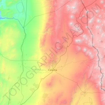
Name: Calama topographic map, elevation, terrain.
Average elevation: 2,653 m
Minimum elevation: 629 m
Maximum elevation: 6,123 m
Make a donation
Other topographic maps
Click on a map to view its topography, its elevation and its terrain.
Toconao
Chile > Antofagasta Region > Provincia de El Loa > San Pedro de Atacama
Toconao is a village 38 km (24 mi) south of San Pedro de Atacama in the San Pedro de Atacama province of Chile's northern Antofagasta Region. It lies at an elevation of 2,485 m (8,153 ft) above sea level, close to the northeast margin of the Salar de Atacama.
Average elevation: 2,488 m
Rainbow Valley
Chile > Antofagasta Region > Provincia de El Loa > San Pedro de Atacama
Average elevation: 3,416 m
Solcor
Chile > Antofagasta Region > Provincia de El Loa > San Pedro de Atacama
Average elevation: 2,427 m