
Tepeören Mahallesi topographic map
Interactive map
Click on the map to display elevation.
About this map
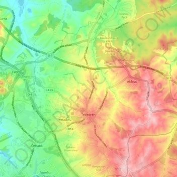
Name: Tepeören Mahallesi topographic map, elevation, terrain.
Average elevation: 152 m
Minimum elevation: 54 m
Maximum elevation: 263 m
Other topographic maps
Click on a map to view its topography, its elevation and its terrain.
Akfırat Mahallesi
Turkey > Tuzla > Akfırat Mahallesi
Akfırat Mahallesi, Tuzla, Istanbul, Marmara Region, 34959, Turkey
Average elevation: 157 m