
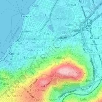
Pazaryeri Mahallesi topographic map
Interactive map
Click on the map to display elevation.
About this map
Name: Pazaryeri Mahallesi topographic map, elevation, terrain.
Average elevation: 43 m
Minimum elevation: 0 m
Maximum elevation: 186 m
Other topographic maps
Click on a map to view its topography, its elevation and its terrain.
Göztepe Mahallesi
Göztepe Mahallesi, Izmir, Konak, Izmir, Aegean Region, Turkey
Average elevation: 38 m
Umurbey Mahallesi
Umurbey Mahallesi, Izmir, Konak, Izmir, Aegean Region, 35230, Turkey
Average elevation: 4 m
Yavuz Selim Mahallesi
Yavuz Selim Mahallesi, Izmir, Konak, Aegean Region, Turkey
Average elevation: 94 m