
Tbilisi topographic map
Interactive map
Click on the map to display elevation.
About this map
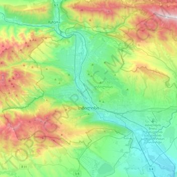
Name: Tbilisi topographic map, elevation, terrain.
Location: Tbilisi, Georgia (41.62039 44.59672 41.84342 45.01801)
Average elevation: 757 m
Minimum elevation: 330 m
Maximum elevation: 1,713 m
Most of the raions are named after historic quarters of the city. The citizens of Tbilisi widely recognise an informal system of smaller historic neighbourhoods. Such neighbourhoods are several, however, constituting a kind of hierarchy, because most of them have lost their distinctive topographic limits. The natural first level of subdivision of the city is into the Right Bank and the Left Bank of the Mt'k'vari.
Other topographic maps
Click on a map to view its topography, its elevation and its terrain.
Batumi
Georgia > Autonomous Republic of Adjara
Batumi, Autonomous Republic of Adjara, Georgia
Average elevation: 121 m
Vake-Saburtalo Raion
Georgia > Tbilisi > Village Dighomi
Vake-Saburtalo Raion, Village Dighomi, Tbilisi, 0135, Georgia
Average elevation: 513 m
Gudauri
Georgia > Mtskheta-Mtianeti > Gudauri
Gudauri, Kazbegi Municipality, Mtskheta-Mtianeti, 4702, Georgia
Average elevation: 2,258 m
Ushba
Georgia > Samegrelo-Upper Svaneti
Ushba, Mestia Municipality, Samegrelo-Upper Svaneti, Georgia
Average elevation: 3,640 m
Mount Mkinvartsveri (Kazbegi)
Mount Mkinvartsveri (Kazbegi), Kazbegi Municipality, Mtskheta-Mtianeti, Georgia
Average elevation: 4,324 m
Stepantsminda
Georgia > Mtskheta-Mtianeti > Stepantsminda
Stepantsminda, Kazbegi Municipality, Mtskheta-Mtianeti, Georgia
Average elevation: 1,855 m
Abano
Georgia > Inner Kartli > Abano
Abano, Kareli Municipality, Inner Kartli, Georgia
Average elevation: 779 m
Caucasus Mountains
Georgia > Mtskheta-Mtianeti > Dusheti Municipality > Chalisopeli
Caucasus Mountains, Chalisopeli, Dusheti Municipality, Mtskheta-Mtianeti, Georgia
Average elevation: 2,188 m
Shkhara
Georgia > Samegrelo-Upper Svaneti
Shkhara, Mestia Municipality, Samegrelo-Upper Svaneti, Georgia
Average elevation: 4,334 m
Zhabeshi
Georgia > Samegrelo-Upper Svaneti > Zhabeshi
Zhabeshi, Mestia Municipality, Samegrelo-Upper Svaneti, Georgia
Average elevation: 1,990 m