
Wurzbach topographic map
Interactive map
Click on the map to display elevation.
About this map
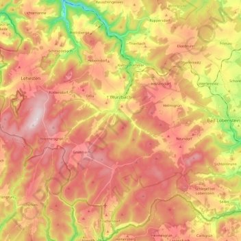
Name: Wurzbach topographic map, elevation, terrain.
Location: Wurzbach, Saale-Orla-Kreis, Thüringen, 07343, Deutschland (50.37398 11.47780 50.52406 11.59210)
Average elevation: 610 m
Minimum elevation: 355 m
Maximum elevation: 790 m
Die Stadt Wurzbach liegt am Nordwestrand des Frankenwaldes an der Sormitz, ist 72,31 km² groß und befindet sich in einer Höhenlage von 500 bis 725 m ü. NHN.
Other topographic maps
Click on a map to view its topography, its elevation and its terrain.
Saalburg
Deutschland > Thüringen > Saale-Orla-Kreis
Saalburg, Saalburg-Ebersdorf, Saale-Orla-Kreis, Thüringen, 07929, Deutschland
Average elevation: 463 m
Ranis
Deutschland > Thüringen > Saale-Orla-Kreis
Ranis, Ranis-Ziegenrück, Saale-Orla-Kreis, Thüringen, 07389, Deutschland
Average elevation: 377 m