
寨子沟乡 topographic map
Interactive map
Click on the map to display elevation.
About this map
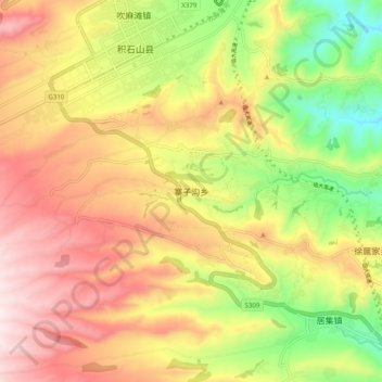
Name: 寨子沟乡 topographic map, elevation, terrain.
Location: 寨子沟乡, 积石山保安族东乡族撒拉族自治县, 临夏回族自治州, 甘肃省, 中国 (35.63975 102.85215 35.71975 102.93215)
Average elevation: 2,318 m
Minimum elevation: 2,027 m
Maximum elevation: 2,586 m
Other topographic maps
Click on a map to view its topography, its elevation and its terrain.
小洼
中国 > 甘肃省 > 积石山保安族东乡族撒拉族自治县 > 马家村
小洼, 马家村, 积石山保安族东乡族撒拉族自治县, 临夏回族自治州, 甘肃省, 中国
Average elevation: 2,200 m