
Thank you for supporting this site ❤️
Make a donation
Make a donation
Brandholz topographic map
Click on the map to display elevation.
Thank you for supporting this site ❤️
Make a donation
Make a donation
About this map
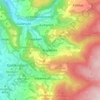
Name: Brandholz topographic map, elevation, terrain.
Average elevation: 565 m
Minimum elevation: 389 m
Maximum elevation: 789 m
Thank you for supporting this site ❤️
Make a donation
Make a donation
Other topographic maps
Click on a map to view its topography, its elevation and its terrain.
Fürstenstein
Deutschland > Bayern > Landkreis Bayreuth > Goldkronach > Brandholz > Beerfleck
Average elevation: 621 m