
Make a donation
Newfoundland and Labrador topographic map
Click on the map to display elevation.
Make a donation
Newfoundland and Labrador
In 1496, John Cabot obtained a charter from English King Henry VII to "sail to all parts, countries and seas of the East, the West and of the North, under our banner and ensign and to set up our banner on any new-found-land" and on June 24, 1497, landed in Cape Bonavista. Historians disagree on whether Cabot landed in Nova Scotia in 1497 or in Newfoundland, or possibly Maine, if he landed at all, but the governments of Canada and the United Kingdom recognise Bonavista as being Cabot's "official" landing place. In 1499 and 1500, Portuguese mariners João Fernandes Lavrador and Pêro de Barcelos explored and mapped the coast, the former's name appearing as "Labrador" on topographical maps of the period.
Make a donation
About this map
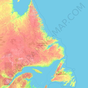
Name: Newfoundland and Labrador topographic map, elevation, terrain.
Location: Newfoundland and Labrador, Canada (46.41019 -67.82169 60.47703 -52.32377)
Average elevation: 192 m
Minimum elevation: -1 m
Maximum elevation: 1,368 m
Make a donation
Other topographic maps
Click on a map to view its topography, its elevation and its terrain.
Toronto
Despite its deep ravines, Toronto is not remarkably hilly, but its elevation does increase steadily away from the lake. Elevation differences range from 76.5 metres (251 ft) above sea level at the Lake Ontario shore to 209 m (686 ft) ASL near the York University grounds in the city's north end at the…
Average elevation: 113 m
London
Canada > Ontario > London > London
London has a humid continental climate (Köppen Dfb), though due to its downwind location relative to Lake Huron and elevation changes across the city, it is virtually on the Dfa/Dfb (hot summer) boundary favouring the former climate zone to the southwest of the confluence of the South and North Thames Rivers,…
Average elevation: 268 m
Guelph
This region of Ontario has cold winters and warm, humid summers, falling into the Köppen climate classification Dfb zone, with moderately high rainfall and snowfall. It is generally a couple of degrees cooler than lower elevation regions on the Great Lakes shorelines, especially so in winter, the exception…
Average elevation: 344 m
Make a donation
Banff
Canada > Alberta > Banff > Banff
Banff is a town within Banff National Park in Alberta, Canada. It is located in Alberta's Rockies along the Trans-Canada Highway, approximately 126 km (78 mi) west of Calgary and 58 km (36 mi) east of Lake Louise. At 1,400 to 1,630 m (4,590 to 5,350 ft) above sea level, Banff is the community with the second…
Average elevation: 1,615 m
Make a donation
Make a donation
Make a donation
Mount Royal
Canada > Quebec > Urban agglomeration of Montreal > Montreal
The hill is part of the Monteregian Hills situated between the Laurentians and the Appalachian Mountains. It gave its Latin name, Mons Regius, to the Monteregian chain. The hill consists of three peaks: Colline de la Croix (or Mont Royal proper) at 233 m (764 ft), Colline d'Outremont (or Mount Murray, in the…
Average elevation: 111 m
Laurentian Mountains
One of Quebec's official regions is called Laurentides. The mountain range runs through four other regions; Capitale-Nationale, Outaouais, Lanaudière, and Mauricie. The elevation generally ranges from around 500 m (1,640 ft) to 1,000 m (3,280 ft) with Mont Raoul-Blanchard being its highest peak, at 1,166 m…
Average elevation: 348 m
Whitecourt
Canada > Alberta > Whitecourt
Whitecourt is a town in central Alberta, Canada within Woodlands County. It is located approximately 177 km (110 mi) northwest of Edmonton and 279 km (173 mi) southeast of Grande Prairie at the junction of Highway 43 and Highway 32, and has an elevation of 690 m (2,260 ft). The Whitecourt meteor impact crater…
Average elevation: 721 m
Make a donation
Krestova
Canada > British Columbia > Regional District of Central Kootenay > Area H (The Slocan Valley)
Average elevation: 640 m
Fairmont Hot Springs
Canada > British Columbia > Regional District of East Kootenay > Area F (Columbia Lake/Windermere Lake)
Average elevation: 920 m
Tory Hill Community Park
Canada > Ontario > Haliburton County > Highlands East
Average elevation: 399 m
Make a donation
Make a donation
Magnetawan River
Canada > Ontario > Parry Sound District > Unorganized Centre Parry Sound
Average elevation: 198 m
Port Coquitlam
Canada > British Columbia > Metro Vancouver Regional District > Port Coquitlam
Average elevation: 185 m
Make a donation
Avalon Peninsula
Canada > Newfoundland and Labrador > Spaniard's Bay > Tilton
Average elevation: 157 m
Turtle Mountain Provincial Park
Canada > Manitoba > Municipality of Boissevain – Morton
Turtle Mountain Provincial Park is situated on the Turtle Mountain (plateau), one of a number of significant geographic features located along the Manitoba Escarpment, the Canadian portion of the Pembina Escarpment. It is located in the Southwest Manitoba Uplands Ecoregion, within the Canadian Prairies. The…
Average elevation: 662 m
Elkwater
Canada > Alberta > Cypress County
The Elkwater townsite lies at an elevation of about 1,225 m (4,025 ft) on the northwest slope of the Cypress Hills which, with a summit at 1,466 m (4810 ft), are the highest point between the Rocky Mountains and Labrador within Canada. Because of the elevation, the area receives more moisture than the…
Average elevation: 1,294 m
Make a donation
Dundas
Canada > Ontario > Hamilton > Dundas
Dundas /ˈdʌnˌdæs/ is a community and former town in Hamilton, Ontario, Canada. It is nicknamed the Valley Town because of its topographical location at the bottom of the Niagara Escarpment on the western edge of Lake Ontario. The population has been stable for decades at about twenty thousand, largely…
Average elevation: 171 m
Make a donation
Naramata
Canada > British Columbia > Regional District of Okanagan-Similkameen > Area E (Naramata/Greyback)
Average elevation: 414 m
Carroll Lake
Canada > Ontario > Kenora District > Unorganized Kenora District
Average elevation: 338 m
Make a donation
Nose Hill Park
Names currently associated with topographical features in and near Nose Hill Park reflect the impact of the European newcomers and European trade goods on the Peigan. For example, Spy Hill, the westward extension of Nose Hill, derived its present name from the aboriginal practice of communicating with distant…
Average elevation: 1,174 m
Make a donation
Mount Logan
Due to active tectonic uplifting, Mount Logan is still rising in height (approximately 0.35 mm per year). Before 1992, the exact elevation of Mount Logan was unknown and measurements ranged from 5,959 to 6,050 metres (19,551 to 19,849 ft). In May 1992, a GSC expedition climbed Mount Logan and fixed the current…
Average elevation: 5,292 m
Make a donation
Anahim Lake
Canada > British Columbia > Cariboo Regional District > Area J (West Chilcotin)
Average elevation: 1,101 m
Make a donation
Make a donation
Mount Robson
Canada > British Columbia > Regional District of Fraser-Fort George > Area H (Robson Valley/Canoe)
The north face can be seen from Berg Lake, and reached by a 19 km (11.8 mi) hike. The lake is approximately 2 km long and lies at 1,646 m (5,400 ft) elevation. There are backcountry campgrounds at each end of the lake and a log shelter on its banks, named Hargreaves Shelter in honor of the Hargreaves family…
Average elevation: 3,042 m
Cochrane
Canada > Alberta > Town of Cochrane > Cochrane
Cochrane is situated at the base of Big Hill in the Bow River Valley. It sits at an elevation of 1,186 m (3,891 ft). The town is intersected by Highway 1A and Highway 22. Cochrane has a reputation for its western culture, which can easily be felt when one wanders the streets (particularly Main Street). The…
Average elevation: 1,205 m
Whistler
Canada > British Columbia > Squamish-Lillooet Regional District > Whistler Resort Municipality > Whistler
Average elevation: 996 m
Make a donation
Peterborough
Canada > Ontario > Peterborough
Peterborough's topography is largely defined by land formations created by the receding Wisconsian glaciers 10,000–15,000 years ago. The South End and Downtown portions of the City sit on what was the bottom of the glacial Lake Peterborough—part of a glacial spillway created when glacial meltwaters from…
Average elevation: 235 m
Make a donation
Mount Begbie
Canada > British Columbia > Columbia-Shuswap Regional District > Area B (Shelter Bay/Mica Creek)
Average elevation: 2,066 m
Cole Lake
Canada > Ontario > Parry Sound District > Unorganized Centre Parry Sound
Average elevation: 216 m
Make a donation
South Hazelton
Canada > British Columbia > Regional District of Kitimat-Stikine > Area B (Suskwa/Kitwanga/Kispiox) > South Hazelton
Average elevation: 278 m
Make a donation
Lockport
Canada > Manitoba > Division No. 13 > Rural Municipality of St. Andrews
Average elevation: 232 m
Shebandowan
Canada > Ontario > Thunder Bay District > Unorganized Thunder Bay District
Average elevation: 461 m
Make a donation
Make a donation
Saint Andrews
Canada > New Brunswick > Charlotte County > Town of Saint Andrews
Average elevation: 7 m
Saanich Peninsula
Canada > British Columbia > Capital Regional District > Central Saanich
Average elevation: 49 m
Make a donation
Make a donation
Crysler
Canada > Ontario > Stormont, Dundas and Glengarry Counties > North Stormont
Average elevation: 69 m
Whitecroft
Canada > British Columbia > Thompson-Nicola Regional District > Area P (Rivers and the Peaks)
Average elevation: 1,000 m
Make a donation
Langley Township
Canada > British Columbia > Metro Vancouver Regional District > Township of Langley > Langley Township
Average elevation: 37 m
Silver Star Mountain Resort
Canada > British Columbia > Regional District of North Okanagan > Area C (Silver Star)
Average elevation: 1,584 m
Make a donation