
Make a donation
Hautes Pyrenees topographic map
Click on the map to display elevation.
Make a donation
Hautes Pyrenees
Hautes-Pyrénées consists of several distinct geographical areas. The southern portion, along the border with Spain, consists of mountains such as the Vignemale, the Pic du Midi de Bigorre, and the Neouvielle and Arbizon ranges. A second area consists of low-altitude rolling hills. The northern part of the département consists of largely flat agricultural land. Hautes-Pyrénées has two small territorial exclaves—a remnant from the Middle Ages—located within the neighboring département of Pyrénées-Atlantiques.
Make a donation
About this map
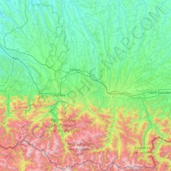
Name: Hautes Pyrenees topographic map, elevation, terrain.
Location: Hautes Pyrenees, Occitania, Metropolitan France, France (42.67418 -0.32723 43.61336 0.64614)
Average elevation: 820 m
Minimum elevation: 91 m
Maximum elevation: 3,280 m
Make a donation
Other topographic maps
Click on a map to view its topography, its elevation and its terrain.
Hôtellerie du Cirque
France > Occitania > Hautes Pyrenees > Gavarnie-Gèdre > Gavarnie
Average elevation: 1,989 m
Make a donation
Pic de Finestrelles
France > Occitania > Pyrénées-Orientales > Eyne
Pic de Finestrelles is a mountain located in the Oriental Pyrenees, on the border of France and Spain. It has an altitude of 2,826 metres (9,272 ft) above sea level.
Average elevation: 2,502 m
Make a donation
Pic de Finestrelles
France > Occitania > Pyrénées-Orientales > Eyne
Pic de Finestrelles is a mountain located in the Oriental Pyrenees, on the border of France and Spain. It has an altitude of 2,826 metres (9,272 ft) above sea level.
Average elevation: 2,502 m
Make a donation
Make a donation
Make a donation
Make a donation
Make a donation
Make a donation
Mont Valier
France > Occitania > Ariège > Seix
On August 18, 2023, French general Jean-Louis Georgelin fell to his death while hiking on Mont Valier, at an altitude of 2,650 metres (8,690 ft).
Average elevation: 2,217 m
Make a donation
Make a donation
Make a donation
Make a donation
Make a donation
Make a donation
Cirque de Gavarnie
France > Occitania > Hautes Pyrenees > Gavarnie-Gèdre > Gavarnie
Average elevation: 2,364 m
Make a donation
Make a donation
Make a donation
Make a donation
Make a donation
Make a donation
Make a donation
La Ville
France > Occitania > Pyrénées-Orientales > Saint-Laurent-de-la-Salanque
Average elevation: 4 m
Make a donation
Lac de Gaube
France > Occitania > Hautes Pyrenees > Cauterets
The lake is situated in an altitude of 1725 m, an egg-shaped form stretching itself along a north–south axis in the valley of Gaube. This steep-sided valley is located at the foot of the Vignemale (3298M). The lake is surrounded by the peak Mayouret (2688 m) to the east, the big Peak of the Paloumères (2720…
Average elevation: 2,079 m
Make a donation
Make a donation
Make a donation