
Thank you for supporting this site ❤️
Make a donation
Make a donation
Licheng District topographic map
Click on the map to display elevation.
Thank you for supporting this site ❤️
Make a donation
Make a donation
About this map
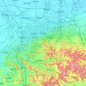
Name: Licheng District topographic map, elevation, terrain.
Location: Licheng District, Jinan, Shandong, 250100, China (36.33044 116.92502 36.89754 117.37682)
Average elevation: 179 m
Minimum elevation: 18 m
Maximum elevation: 939 m
Thank you for supporting this site ❤️
Make a donation
Make a donation
Other topographic maps
Click on a map to view its topography, its elevation and its terrain.