
Thank you for supporting this site ❤️
Make a donation
Make a donation
Taki topographic map
Click on the map to display elevation.
Thank you for supporting this site ❤️
Make a donation
Make a donation
Taki
Taki is located at 22°35′N 88°55′E / 22.59°N 88.92°E / 22.59; 88.92. It has an average elevation of 5 metres (16 feet) at the bank of Ichamati River.
Thank you for supporting this site ❤️
Make a donation
Make a donation
About this map
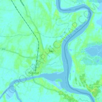
Name: Taki topographic map, elevation, terrain.
Average elevation: 4 m
Minimum elevation: -3 m
Maximum elevation: 14 m
Thank you for supporting this site ❤️
Make a donation
Make a donation